


Business Solutions
The World Through Large Format Mapping and Geospatial Imagery
Imagine being able to see the Earth from above, capturing every intricate detail, whether it’s the vast expanse of a desert or the detailed layout of a city. Large format mapping for geospatial imagery allow us to experience the world in a way that was once unimaginable. These technologies provide a bird’s-eye view of our planet, enabling a deeper understanding of the landscapes we live in and the changes occurring within them. From urban development to environmental monitoring, large format mapping and geospatial imagery have become vital tools for industries across the globe.
As you dive deeper into the world of geospatial imagery, consider how this data can revolutionize your approach to managing resources, planning cities, or studying environmental changes. Large format mapping allows us to capture landscapes at unprecedented resolutions, while geospatial imagery helps create a more detailed, accurate picture of the world around us.
The Power of Large Format Mapping: A Closer Look
Large format mapping is far more than just creating maps; it is about capturing entire landscapes at an extraordinary level of detail. Unlike traditional methods that offer a broad overview, large format maps can reveal small features of an area, such as individual buildings, roads, and even vegetation types. The power of this technology lies in its ability to present an area in a highly accurate and scalable format, making it an indispensable tool for numerous industries.
For example, when used for urban planning, large format maps provide an in-depth view of both natural and man-made features, enabling planners to design more efficient, sustainable cities. Detailed maps also help city officials track growth patterns, monitor infrastructure, and plan for future expansions. In environmental management, the high level of detail allows for tracking subtle changes in ecosystems, making it easier to observe the effects of climate change or other environmental factors.
Benefits of Large Format Mapping:
- Accuracy: Captures fine details that traditional maps miss.
- Scalability: Provides information at different levels of zoom, from large regions to smaller areas.
- Real-time data: Facilitates continuous updates, providing timely information.
- Application versatility: Useful in urban planning, environmental monitoring, and disaster management.
The role of large format mapping doesn’t stop at static images. When combined with modern technologies like drones and satellites, it enables real-time mapping, offering up-to-date imagery that can be used for quick decision-making in fields like disaster response or emergency planning. Geospatial imagery offers similar benefits, as it brings these images to life through the power of digital technology, providing layers of information that enhance the map’s value.
Geospatial Imagery: The Eyes That See the Earth
Geospatial imagery refers to the visual representation of Earth’s surface, captured through remote sensing technologies such as satellites, drones, and aircraft. This imagery has become an essential part of our understanding of the planet, allowing for comprehensive data collection over vast areas in a fraction of the time it would take to gather manually. The technology behind geospatial imagery includes the use of high-resolution sensors and advanced cameras capable of capturing the world in remarkable detail.
One of the key benefits of geospatial imagery is the ability to view areas that are otherwise difficult or impossible to reach. For instance, remote regions like the Arctic or dense forests can be observed with ease, providing valuable information about the environment, biodiversity, and even human activities in those areas. When applied to areas that are continuously changing—such as urban environments or agricultural lands—geospatial imagery allows for constant monitoring and analysis, ensuring that important patterns and shifts are recognized promptly.
Uses of Geospatial Imagery:
- Urban planning: Monitoring land use, identifying growth patterns, and assessing infrastructure.
- Environmental conservation: Tracking deforestation, land degradation, and changes in ecosystems.
- Agriculture: Monitoring crop health, detecting diseases, and optimizing farming practices.
- Disaster response: Assessing damage after natural disasters and coordinating recovery efforts.
By integrating geospatial imagery with large format mapping, the resolution and detail of these images are significantly enhanced, making it easier to derive actionable insights from the data. Whether it’s identifying areas of urban sprawl or detecting the subtle shifts in agricultural land use, this combination allows for a richer understanding of our world.
From Aerial Views to Data-Driven Insights: Mapping the Globe
The transition from paper maps to digital mapping has been revolutionary, bringing the world closer through detailed, accurate, and interactive representations. Aerial views have long been an essential tool in understanding Earth’s layout, but with the advent of large format mapping and geospatial imagery, the potential of these aerial views has grown exponentially. Today, technologies like satellites and drones allow for global coverage of Earth, providing detailed imagery that is frequently updated.
For example, satellite images can offer a comprehensive view of large-scale events, such as deforestation or the expansion of cities. When combined with large format mapping, the data can be analyzed more precisely, making it possible to predict future trends and address issues before they become more severe. The data captured is often combined with other layers of information, such as population density or land use, to create a comprehensive understanding of how different factors interact across the globe.
Advantages of Digital Mapping:
- Global coverage: Satellites and drones can capture imagery from almost anywhere on Earth.
- Frequent updates: Real-time or near-real-time updates allow for timely decisions.
- Data integration: Combining multiple data layers for enhanced analysis and insights.
- Enhanced accuracy: Higher resolution compared to traditional mapping methods.
Geospatial imagery not only provides a view of Earth’s surface but also enables better decision-making through data integration and interpretation. By creating a visual representation of geographical data, planners, scientists, and decision-makers can analyze patterns and trends that might otherwise go unnoticed. This ability to see both the broad picture and the fine details is what makes large format mapping and geospatial imagery so valuable.
Exploring the Landscape: The Benefits of Large Format Mapping
One of the primary advantages of large format mapping is the level of detail it offers. Traditional maps often provide a broad overview, while large format maps zoom in on specific areas, offering precise measurements and high-resolution imagery. This level of detail is essential for a variety of applications, from urban planning to environmental monitoring.
For example, in agriculture, large format mapping helps farmers monitor crop health by identifying issues such as soil erosion, crop disease, or water stress. In cities, large format maps are used to monitor infrastructure, identify traffic congestion, and track urban sprawl. By offering a clearer picture of these areas, large format mapping allows for more informed decision-making, which can lead to improved sustainability and efficiency.
Furthermore, large format mapping supports long-term planning and decision-making by enabling the tracking of changes over time. Geospatial imagery adds a dynamic element, allowing for the monitoring of the same location through time, which is valuable in industries like environmental science, where understanding change is crucial.
Key Benefits of Large Format Mapping:
- Detailed imagery: Captures fine details such as terrain features, buildings, and roads.
- Precise measurements: Essential for accurate planning and monitoring.
- Long-term tracking: Allows for the observation of changes over time.
- Versatility: Can be applied to various fields, from agriculture to urban development.
Enhance your strategic planning with large format mapping and geospatial imagery. Unlock the potential for more informed, data-driven decisions today.
Through the Lens of Geospatial Imagery: Understanding Our Environment
Geospatial imagery plays a significant role in monitoring and understanding environmental changes. With the ability to capture large areas in great detail, it offers a comprehensive view of the environment, from the condition of forests to the health of oceans. Through the lens of this technology, we can track phenomena like deforestation, melting glaciers, and the spread of pollution with unprecedented accuracy.
In conservation efforts, geospatial imagery helps monitor ecosystems and wildlife, making it easier to identify areas in need of protection or restoration. This ability to see and analyze environmental changes as they happen is crucial in today’s world, where climate change is rapidly altering ecosystems across the globe. By combining large format mapping with geospatial imagery, researchers can track changes in landscapes and ecosystems, assess their impact, and develop targeted strategies to address environmental challenges.
Applications in Environmental Monitoring:
- Deforestation tracking: Monitoring forest health and deforestation rates.
- Climate change studies: Observing the melting of glaciers and rising sea levels.
- Wildlife conservation: Identifying protected areas and tracking animal populations.
- Pollution monitoring: Identifying areas impacted by pollution, including water bodies and air quality.
When it comes to natural disasters, geospatial imagery is invaluable. It allows for the rapid assessment of damage and helps coordinate relief efforts. Large format mapping provides the detailed geographic data needed for effective disaster response, ensuring that resources are allocated where they are most needed.
Building Smart Cities: Large Format Mapping in Urban Development
In the age of rapid urbanization, large format mapping and geospatial imagery are playing an increasingly vital role in shaping the cities of tomorrow. These technologies provide urban planners with the data they need to design sustainable cities, manage resources efficiently, and plan for future growth. By offering a detailed view of existing infrastructure, large format mapping enables city planners to identify areas in need of development or improvement.
In smart city planning, large format mapping is crucial for managing everything from traffic patterns to energy consumption. Geospatial imagery helps planners visualize how different systems within a city—such as transportation, utilities, and healthcare—interact, enabling them to create more integrated, efficient urban environments.
As cities continue to grow, large format mapping allows for real-time updates that inform decision-making. This ongoing data stream ensures that urban development is not only smart but also adaptable to future needs.
Navigating Challenges: How Large Format Mapping Enhances Disaster Response
One of the most impactful applications of large format mapping and geospatial imagery is in disaster response. Whether it’s a hurricane, earthquake, or wildfire, these technologies allow emergency services to quickly assess the situation and deploy resources where they are most needed. Real-time geospatial imagery provides an up-to-date view of the affected areas, allowing for swift decision-making and targeted action.
Large format mapping helps responders navigate challenging terrains and locate critical infrastructure such as hospitals, roads, and power stations. By offering detailed, accurate maps of the disaster area, these technologies enable faster recovery and reduce the impact of such events.
Through the integration of real-time data, large format mapping provides continuous updates, ensuring that response efforts remain aligned with the evolving situation on the ground. The ability to track the progress of a disaster and respond accordingly is a major advantage in minimizing damage and saving lives.
Future Perspectives: The Evolving World of Geospatial Technology
The future of large format mapping and geospatial imagery is bright, with emerging technologies set to expand their potential even further. Advancements in artificial intelligence (AI) and machine learning are making it possible to process and analyze vast amounts of geospatial data with greater efficiency. This means that in the future, large format mapping could offer even higher resolutions and provide more accurate predictions for everything from urban planning to climate modeling.
The integration of AI with geospatial imagery is also making it easier to identify patterns and trends, offering actionable insights that were previously hidden. These innovations will undoubtedly lead to even more powerful tools for environmental monitoring, disaster response, and urban planning, further highlighting the importance of these technologies.
A New Way of Seeing the World
Large format mapping and geospatial imagery are changing the way we see the world. These technologies provide a deeper understanding of the Earth’s landscapes and enable us to make more informed decisions in everything from urban development to environmental conservation. As technology continues to evolve, the possibilities for these tools are limitless, offering a new lens through which to view and protect our planet.
By embracing large format mapping and geospatial imagery, we unlock the ability to see our world with greater clarity, detail, and foresight. The potential for progress in countless fields is limitless, making these technologies essential for the future.
Frequently Asked Questions
- What is large format mapping?
- Large format mapping is a method of capturing geographical data with a high level of detail, offering precise measurements and high-resolution imagery. This technology is used for various applications like urban planning, agriculture, and environmental management.
- How does geospatial imagery differ from traditional maps?
- Geospatial imagery captures detailed visual data of Earth’s surface through technologies like satellites, drones, and aircraft, offering real-time updates and higher resolution compared to traditional static maps.
- What are the main benefits of large format mapping?
- Large format mapping provides enhanced accuracy, scalability, and the ability to track changes over time, making it an essential tool for industries like urban planning, agriculture, and disaster response.
- How is geospatial imagery used in urban development?
- Geospatial imagery helps urban planners design efficient, sustainable cities by offering detailed views of infrastructure, land use, and environmental factors, assisting in better planning and resource management.
- Can geospatial imagery track environmental changes?
- Yes, geospatial imagery is crucial for monitoring environmental changes such as deforestation, climate change effects, and pollution, providing valuable data for conservation efforts and policy decisions.
- How does large format mapping contribute to disaster response?
- Large format mapping provides detailed, real-time imagery of disaster areas, helping emergency responders assess damage, locate critical infrastructure, and allocate resources more efficiently.
- What role does AI play in geospatial imagery and mapping?
- AI is enhancing geospatial imagery by automating data processing and analysis, identifying patterns, and improving the accuracy of predictions, thus optimizing the use of large format mapping in various industries.

מבוא
שוק הבנייה הישראלי עומד בפני שינוי מבני מואץ. לחצי עלות, מחסור בכוח אדם מיומן, עליות בחומרי גלם וגידול בביקוש לדיור – כל אלה מאלצים חברות בנייה לחפש יעילות מקומות שלא חיפשו קודם. הפתרון מגיע מהטכנולוגיה. בשנת 2025, חמש טכנולוגיות עומדות במרכז הטרנספורמציה הדיגיטלית של הענף – וחברות שמאמצות אותן מוקדם יותר יהנו מיתרון תחרותי משמעותי. ConWize היא דוגמה לפלטפורמה ישראלית שמשלבת כמה מהכלים הללו – אומדן, תמחור וניהול מכרזים – בפתרון אחד מאוחד, שנבנה על הצרכים הספציפיים של שוק הבנייה המקומי.
טכנולוגיה 1: BIM – מידול מידע לבניין
BIM (Building Information Modeling) אינה עוד חידוש – היא הופכת לסטנדרט עבודה. BIM מאפשרת יצירת מודל תלת-ממדי דיגיטלי של הבניין שכולל לא רק גיאומטריה אלא גם נתוני עלות, לוחות זמנים, מפרטים טכניים ותחזוקה עתידית.
אנגליה מחייבת BIM בכל מבנה ציבורי מ-2016
ישראל צפויה להרחיב דרישות BIM בפרויקטי תשתיות ממשלתיים ב-2025–2026
חיסכון ממוצע: 5–10% בעלויות בנייה, 20% בשגיאות תכנוני
טכנולוגיה 2: ניהול אומדן ותמחור בענן
גיליונות Excel אינם מספיקים יותר כשמנהלים מספר פרויקטים מורכבים בו-זמנית. פתרונות ענן לאומדן מאפשרים גישה בכל מקום, שיתוף פעולה בזמן אמת ועדכון מחירים אוטומטי. פלטפורמת ConWize לאומדן ותמחור מייצגת את הדור הבא של כלים אלה: ממשק עברי, כתב כמויות מובנה, ניהול מכרזים ושליטה בתקציב – הכל מקום אחד.
חיסכון ממוצע בזמן אומדן: 35–50%
ירידה בשגיאות תמחור: עד 70%
זמינות מהשטח: עדכון ומעקב ישירות מהסמארטפון
טכנולוגיה 3: פלטפורמות ניהול פרויקטים בענן
כלים כמו Procore, PlanGrid ומקבילות ישראליות מאפשרות ניהול לוחות זמנים, עבודות וחוזים מרכזי – עם ניראות מלאה לכל בעלי העניין בפרויקט. לפי Dodge Data & Analytics, חברות שמשתמשות בפלטפורמות ניהול פרויקטים מדווחות על עמידה בלוחות זמנים גבוהה ב-30% לעומת חברות שאינן משתמשות.
ניהול RFI ותוכניות ישירות מהאפליקציה
תיעוד אוטומטי של כל החלטה ואירוע בשטח
דשבורד סטטוס לכל קבלן ומשימה
טכנולוגיה 4: ניתוח נתוני שטח ו-IoT
חיישנים, מצלמות ומכשירי IoT שמוצבים באתר הבנייה מאפשרים מעקב בזמן אמת אחר התקדמות עבודות, שימוש בציוד ותנאי בטיחות. הנתונים מוזנים לפלטפורמות ניתוח שמאפשרות לזהות עיכובים, בזבוז ומפגעי בטיחות לפני שהם הופכים לבעיות.
ניטור ממשי של שעות עבודה ונוכחות
מעקב GPS אחר ציוד וכלי רכב
התראות בטיחות אוטומטיות
טכנולוגיה 5: בינה מלאכותית לתמחור ואומדן
הדור הבא של כלי האומדן משלב בינה מלאכותית שמנתחת פרויקטים קודמים ומחירי שוק כדי לייצר אומדנים מדויקים יותר. מערכות AI מסוגלות לזהות חריגות, להצביע על סיכוני עלות ולהציע חלופות תכנוניות זולות יותר – כל זאת בשבריר מהזמן שצוות אנושי היה זקוק לו.
לפי סקר Autodesk מ-2024, 68% ממנהלי הפרויקטים בעולם מאמינים ש-AI תהיה מרכזית בתמחור ואומדן תוך שלוש שנים.
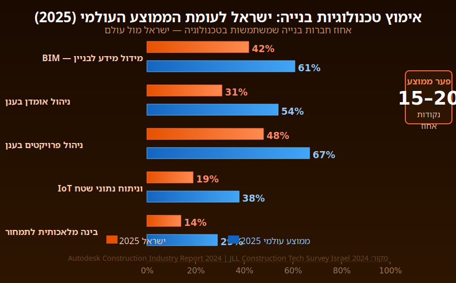
טבלת השוואה: שיעורי אימוץ טכנולוגיות בנייה בישראל (2025)
| טכנולוגיה | שיעור אימוץ (ישראל) | שיעור אימוץ (עולמי) |
| BIM | 42% | 61% |
| ניהול אומדן בענן | 31% | 54% |
| ניהול פרויקטים בענן | 48% | 67% |
| IoT וניתוח שטח | 19% | 38% |
| AI לתמחור ואומדן | 14% | 29% |
מקור: Autodesk Construction Industry Report 2024; JLL Construction Tech Survey Israel 2024
מה שוק הבנייה בישראלי צריך לדעת
ישראל מאמצת טכנולוגיות בנייה בקצב איטי יותר מהממוצע העולמי – אך הפער מצטמצם. הנהגת מחייבת BIM בפרויקטים ציבוריים, עלייה בהיקפי הבנייה ותחרות גוברת על כוח אדם מיומן יוצרים לחץ שמאיץ את קצב האימוץ. חברות שיתחילו את המעבר הדיגיטלי עכשיו ייהנו מיתרון ראשון-מגיע שיהיה קשה לשחזר בעוד שלוש שנים.
התחילו בכלי ה-ROI המהיר ביותר: ניהול אומדן ותמחור דיגיטלי
צרו מסד נתונים פנימי של עלויות מפרויקטים קודמים
השקיעו בהכשרת צוות – הטכנולוגיה טובה בדיוק כמו האנשים שמשתמשים בה
בחרו פלטפורמה עם תמיכה מקומית ותיעוד בעברית
סיכום
הטרנספורמציה הדיגיטלית של שוק הבנייה הישראלי אינה שאלה של ‘אם’ אלא של ‘מתי’. הכלים שפעם היו נחלת חברות הבנייה הגדולות ביותר בעולם הפכו נגישים, מותאמים מקומית ומוכחים בשטח. חברות שישכילו לאמץ טכנולוגיות אלה יוכלו לנהל פרויקטים מורכבים יותר, לשמור על שולי רווח בריאים ולספק ללקוחות שלהן רמת מקצועיות שהמתחרים לא יוכלו להציע. זהו הרגע לפעול
Business Solutions
Conwize: Quoting Software for Builders with Integrated Construction Bid Management
In competitive construction markets, how you quote is as important as what you quote. Builders and contractors that produce fast, accurate, professionally presented quotations – and that track their bidding activity systematically through a structured construction bid management software – consistently win more work at better margins than those who treat quoting as a reactive administrative task. Conwize is built on this insight, providing quoting software for builders that transforms pre-construction commercial operations from a pressure point into a competitive advantage.
The Commercial Cost of Inadequate Quoting Tools
The construction industry’s quoting and bidding function consumes a substantial proportion of a contracting business’s overhead – estimating teams, bid coordinators, quantity surveyors, and management time all contribute to the cost of pursuing work that may or may not be won. Industry benchmarks suggest that the estimating cost per bid ranges from 0.1% to 0.5% of project value for sophisticated estimating operations, and considerably more for businesses using manual, inefficient processes.
The opportunity cost of inadequate quoting software for builders is even larger. Teams hampered by slow, manual quoting processes cannot pursue as many tenders as the market makes available. Errors in manually assembled quotes – whether missed cost items, transposition errors, or outdated subcontractor prices — either cost margin when not caught before submission or cost the bid when detected by the client during evaluation. And the lack of systematic construction bid management means that business development intelligence – which project types are most winnable, which clients award most reliably, which geographies have the best margin potential – is never captured or analyzed.
Conwize addresses all three dimensions of this challenge: faster quoting through workflow automation, more accurate quotes through integrated subcontractor pricing, and richer bid intelligence through systematic pipeline management.
How Conwize’s Quoting Workflow Works for Builders
When a tender invitation arrives, Conwize’s quoting workflow begins with a single project setup action: the estimator creates a new project, loads the tender documents, and structures the scope into trade packages. From this point, the entire quoting process runs within Conwize – with no information escaping into external spreadsheets or email threads that cannot be tracked or controlled.
The subcontractor quotation process — typically the most time-consuming element of any builder’s quoting workflow – is where Conwize delivers its most immediate time savings. Scope packages are prepared within the platform and distributed to selected subcontractors in a single action. Subcontractors receive a structured invitation with all relevant documents attached. Response receipt is tracked automatically. Reminder notifications go out to non-responding subcontractors without manual chasing. And received quotations are loaded into Conwize’s bid comparison interface for structured analysis.
The bid comparison and leveling interface presents all received subcontractor quotations side by side against the scope items, automatically calculating adjusted totals that account for scope gaps, and flagging the most competitive compliant offer for each package. What takes a day or more of manual analysis in a spreadsheet is accomplished in Conwize in under an hour — with a complete, documented audit trail of the comparison.
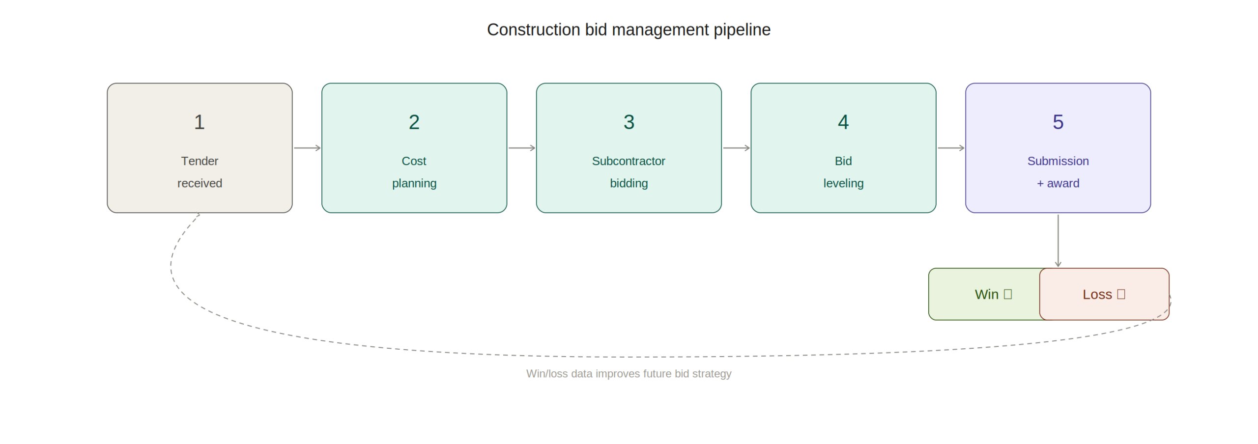
Construction Bid Management: The Strategic Layer Above Quoting
Quoting individual tenders is a tactical activity; construction bid management is the strategic framework that ensures the quoting function serves the business’s commercial objectives. Effective bid management means having a clear, systematically applied bid/no-bid decision process, a structured pipeline of active tenders with visibility of deadlines and resource requirements, and a rigorous post-submission win/loss analysis process that feeds continuous improvement of the bidding strategy.
Conwize’s bid management capability provides all three elements. The pipeline dashboard gives construction directors and business development managers a real-time view of every active tender – project value, client, submission deadline, responsible estimator, and current status. This visibility enables informed bid/no-bid decisions on new opportunities and supports resource allocation decisions that ensure the most commercially important bids receive appropriate attention.
For a detailed breakdown of how systematic construction bid management transforms pre-construction commercial operations, Conwize’s dedicated article on construction bid management covers the key components — from pipeline design to win/loss analysis frameworks — in detail. The discipline of managing bids systematically rather than reactively is one of the most significant changes a construction business can make to its commercial performance.
Subcontractor Management Within the Quoting Platform
The quality of a builder’s subcontractor network is a direct determinant of the quality of their quotations – and managing that network effectively requires more than a contacts list. Conwize’s subcontractor database tracks each subcontractor’s trade coverage, geographic range, response rate, historical pricing competitiveness, and performance on awarded projects — providing the intelligence needed to assemble the best tender list for each trade package on each new project.
Over time, this intelligence compounds: estimators can see which subcontractors consistently respond with competitive prices for specific trade types, which tend to submit incomplete scope, and which have the highest award rates. This data-driven tender list selection is a significant quality improvement over the informal, relationship-based subcontractor selection that most builders currently practice.
The Conwize subcontractor portal – through which subcontractors receive invitations, submit quotations, and track their own bid history – is designed for ease of use from the subcontractor’s perspective, increasing response rates and improving the quality of received quotations.
Frequently Asked Questions
Q1: What is quoting software for builders and how does it differ from generic estimating tools?
A: Quoting software for builders is specifically designed for the construction quoting workflow – managing the complete process from scope definition through subcontractor bid management to submission document generation. Generic estimating tools focus on cost calculation; purpose-built quoting software manages the entire commercial workflow surrounding that calculation.
Q2: What is construction bid management and why is it important?
A: Construction bid management is the systematic process of tracking, coordinating, and analyzing the full bidding lifecycle – from tender identification and bid/no-bid decision through to submission, award, and win/loss review. Systematic bid management transforms bidding from a reactive activity into a managed commercial function with measurable performance improvement over time.
Q3: How does Conwize’s quoting workflow save time for builders?
A: Conwize automates the most time-consuming elements: subcontractor invitation and tracking (replacing manual email management), bid leveling (replacing manual spreadsheet comparison), and submission document generation (replacing manual reformatting). These automations typically reduce quoting time by 30-50% per tender.
Q4: Can Conwize track multiple simultaneous tenders in the bid pipeline?
A: Yes. Conwize’s pipeline dashboard displays all active tenders – value, deadline, client, status, and responsible estimator – in a single management view. This enables directors to allocate estimating resources, make bid/no-bid decisions, and track portfolio-level bidding activity in real time.
Q5: How does Conwize support post-bid win/loss analysis?
A: Conwize records bid outcomes — win/loss status, awarded value, client, project type, and geographic location – enabling systematic analysis of win rates by project type, client sector, tender value range, and other dimensions. This intelligence informs continuous improvement of bidding strategy and target market selection.
Q6: Does Conwize help with subcontractor response rates on quotation requests?
A: Yes. Conwize sends automated follow-up reminders to subcontractors who have not responded to quotation invitations, significantly improving response rates without manual chasing. The subcontractor portal provides a simple, accessible submission interface that further encourages response.
Q7: Is Conwize suitable for both residential builders and commercial contractors?
A: Conwize serves both residential builders managing volume quoting workflows and commercial contractors pursuing complex multi-trade tenders. The platform scales from straightforward residential quotations to sophisticated commercial BOQ-based estimates with comprehensive subcontractor bid management.
Business Solutions
Conwize for Building Costing and Construction Budgeting: Platform Overview and Key Capabilities
At a Glance
- Building costing is the financial foundation of every construction project – establishing the cost baseline against which all scope changes, subcontractor prices, and project decisions are measured from concept through to completion.
- Construction budgeting software has evolved from static spreadsheet tools into dynamic platforms that connect cost plans to live market pricing, subcontractor quotations, and real-time cost reporting — delivering the cost intelligence that drives profitable project delivery.
- Conwize serves general contractors, head contractors, and specialty contractors who need accurate, auditable building cost plans that can be produced efficiently, reviewed collaboratively, and updated automatically as pricing and scope evolve.
- Conwize’s competitive advantage is the integration of building costing, subcontractor bid management, and tender pipeline tracking in a single cloud-native platform – eliminating the disconnected tools and manual processes that inflate estimating overhead and introduce commercial risk.
The financial outcome of a construction project is largely determined before construction begins – by the quality of the building costing process that establishes the project budget and the rigor of the construction budgeting software that supports it. Conwize was designed by people who understand this reality: that accurate, efficient, and continuously updated cost plans are not just an estimating deliverable but the commercial architecture that underpins every profitable project.
Building Costing: The Foundation of Project Commercial Management
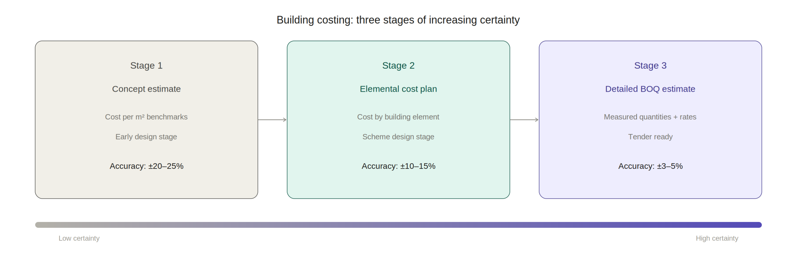
Building costing encompasses the complete process of estimating and managing the cost of constructing a built asset – from the initial elemental cost plan produced at concept design stage through to the detailed BOQ-based budget prepared for tender, and the live cost reporting that tracks actual versus budget throughout delivery. Each stage has different information requirements, different levels of certainty, and different commercial implications.
At the concept stage, building costing relies on parametric benchmarks – cost per square meter by building type, elemental cost ratios, and market intelligence about prevailing construction costs in the relevant geography. At the scheme design stage, an elemental cost plan breaks the building cost into functional elements (substructure, superstructure, envelope, fit-out) with budgets for each based on more developed design information. At the tender stage, the detailed building costing exercise produces a priced BOQ based on measured quantities and actual subcontractor and supplier prices.
Conwize supports all three stages within a single platform – allowing the cost plan to evolve from parametric concept estimate through to detailed tender cost without losing data continuity. The concept stage assumptions are retained as audit trail as the estimate develops, providing a clear picture of how cost certainty has improved through the design process. For a comprehensive guide to building costing methodology, Conwize’s dedicated resource at the Estimating Building Costing guide covers each stage in detail.
Why Traditional Construction Budgeting Software Falls Short
The most common construction budgeting software tool in the industry is still the spreadsheet — and its limitations are well understood. Spreadsheet cost plans break under collaborative use, with version control chaos when multiple team members need to update the same document. They lack integration with live pricing, requiring manual re-entry of subcontractor quotations. They provide no portfolio-level visibility into multiple simultaneous estimates. And they produce no automatic reporting, requiring manual extraction and reformatting of cost data for every client or management report.
Legacy desktop estimating tools solve some of these problems but introduce others. They provide more structure than spreadsheets and typically include cost database functionality, but their desktop architecture prevents genuine multi-user collaboration and remote access. Updates require manual installation, and data backup depends on individual users’ practices rather than automatic cloud sync.
Cloud-native construction budgeting software like Conwize addresses all of these limitations simultaneously. Real-time collaboration, automatic cloud backup, live pricing integration, and portfolio-level reporting are all native capabilities – not bolt-on features. This architectural advantage is the fundamental reason cloud platforms are displacing legacy tools as the standard for professional construction estimating operations.
Conwize’s Building Costing Workflow
Conwize structures building costing within a consistent, project-level cost breakdown that mirrors the actual trade package structure of construction projects. Estimators work within a defined hierarchy – from high-level elemental groups down to individual trade packages and line-item cost components — providing both the structure needed for management-level reporting and the detail needed for subcontractor procurement.
The platform’s assembly library enables estimators to build trade package budgets from pre-configured assemblies of labor, material, and plant components – applying regional rate adjustments and project-specific escalations to produce location-calibrated estimates. For projects where a client-provided BOQ is available, Conwize supports direct import of BOQ items, allowing the cost plan to be structured around the client’s measurement framework rather than an internally developed structure.
Subcontractor pricing integration is where Conwize’s building costing capability differentiates most significantly from spreadsheet and legacy alternatives. Estimators can issue RFQ packages directly from cost plan line items, receive quotations back into the platform, and automatically update the relevant budget items with received prices – replacing the manual data re-entry that introduces errors and delays in spreadsheet-based workflows. The live budget position updates in real time as pricing is received, giving management a continuously current view of cost plan status.
Real-Time Cost Reporting and Budget Tracking
The most valuable aspect of Conwize as construction budgeting software is the live reporting capability that transforms cost planning from a periodic exercise into a continuous operational intelligence function. Project directors can access the current cost plan status at any time – seeing which packages have been priced, which subcontractor quotations are outstanding, what the projected final cost looks like against the budget, and where cost risk is concentrated.
This live visibility is particularly valuable in fast-moving tender environments where subcontractor pricing is arriving right up to submission deadline. Rather than scrambling to update a spreadsheet cost plan manually with last-minute prices and hoping the totals are correct, Conwize users have a live cost total that updates automatically as each quotation is received – enabling confident bid submission even when pricing arrives late.
Conwize’s reporting layer generates client-ready cost plan documents, internal management summaries, and audit-trail reports directly from the platform’s live cost data – eliminating the manual reformatting step that typically consumes 10-15% of estimating team time in manual cost planning processes. Explore the full platform capability for general contractors at conwize.io, and for expert analysis of how digital tools are transforming construction cost management, techpr.online provides regular coverage of construction technology innovation.
Managing Cost Risk and Contingency in Building Projects
Every building cost plan carries uncertainty – from design incompleteness at early stages to market pricing volatility throughout the project duration. Professional building costing practice requires systematic identification and quantification of this uncertainty, and Conwize supports formal cost risk management within the estimating workflow.
Estimators can apply percentage-based or absolute contingency provisions at any level of the cost breakdown – from individual line items through to trade package totals and overall project budget. High-uncertainty items can be flagged for management attention, and sensitivity analysis scenarios can be modeled to show how the budget changes under different pricing assumptions.
Over time, Conwize’s historical data accumulation enables increasingly sophisticated risk management: as actual subcontractor prices from completed projects are retained in the platform, estimators can benchmark current estimates against empirical historical data, identifying systematic biases in their pricing assumptions and calibrating contingency provisions with greater confidence.
Frequently Asked Questions
Q1: What is building costing and how does it differ from construction estimating?
A: Building costing refers broadly to the process of establishing and managing a project’s cost – from early parametric cost plans at concept design through to detailed tender estimates. Construction estimating typically refers specifically to the detailed cost build-up produced for tender submission. Both functions are supported within Conwize’s single integrated platform.
Q2: What makes Conwize different from spreadsheet-based construction budgeting software?
A: Conwize provides real-time multi-user collaboration, live subcontractor pricing integration, automatic reporting, and portfolio-level pipeline visibility – capabilities that spreadsheets architecturally cannot deliver. It also maintains data continuity from concept estimate through to subcontract award, eliminating the version-control and data re-entry problems that spreadsheet workflows produce.
Q3: Can Conwize handle both elemental cost planning and detailed BOQ estimating?
A: Yes. Conwize supports parametric and elemental cost planning at early design stages, and detailed BOQ-level estimating for tender submission – within the same project, maintaining data continuity as the estimate develops from concept through to detailed submission.
Q4: How does Conwize integrate subcontractor pricing into the building cost plan?
A: Conwize allows estimators to issue RFQ packages directly from cost plan items and receive quotations back into the platform. Received prices automatically update the relevant budget items, and the live cost total reflects the current pricing position in real time – no manual re-entry required.
Q5: What cost risk management features does Conwize provide?
A: Conwize supports percentage-based and absolute contingency provisions at any level of the cost breakdown, sensitivity scenario modeling, and flagging of high-uncertainty items. Historical cost comparison against completed projects further informs contingency calibration.
Q6: How does Conwize’s reporting capability work for building cost plans?
A: Conwize generates client-ready cost plan documents, management summaries, and audit-trail reports directly from the live cost data – eliminating manual reformatting. Reports update automatically as new pricing is received or scope changes are incorporated.
Q7: Is Conwize suitable for contractors who receive client-provided BOQs to price?
A: Yes. Conwize supports import of client-provided BOQs in CSV and Excel formats, allowing estimators to work within the client’s measurement framework rather than rebuilding the cost structure from scratch. Subcontractor prices can be linked directly to imported BOQ items.

Targeted Vertical Incubation: Strategic Alignment in Technical Software Venture Co-Investments

The Critical Technical SEO Audit Checklist for Enterprise SaaS Environments

Shadow AI Detection: Regaining Visibility Over Unsanctioned Enterprise Tooling

-

 Business Solutions2 years ago
Live Video Broadcasting with Bonded Transmission Technology
-

 Business Solutions1 year ago
The Future of Healthcare SMS and RCS Messaging
-
 Business Solutions2 years ago
2-Way Texting Solutions from Company Message Services
-

 Business Solutions2 years ago
Communication with Analog to Fiber Converters & RF Link Budgets
-

 DSRC Communication1 year ago
The Crossroads of Connectivity: DSRC vs. C-V2X Technologies in Automotive Communication
-
Electronics3 years ago
AI Modules and Smart Home Chips: Future of Home Automation
-

 Business Solutions2 years ago
Wholesale SMS Platforms with OTP Services
-

 Business Solutions1 year ago
Choosing the Right B2B Digital Marketing Agency: A Guide