
Photography
Drone Photogrammetry: How High-Resolution UAV Cameras Are Transforming Surveying and Mapping
The surveying and mapping industry is undergoing one of its most significant technological shifts in a generation. Drone photogrammetry — the process of deriving accurate 2D maps and 3D models from overlapping aerial photographs taken by UAVs — has moved from experimental technology to an industry standard in a remarkably short period.
The reason is straightforward: drone-based photogrammetry delivers spatial data that is more accessible, more cost-effective, and in many cases more accurate than traditional ground-based or manned aircraft survey methods. The critical variable in this equation is the quality of the imaging system. When the cameras are capable of capturing the resolution and geometric precision that photogrammetric algorithms require, the results are transformative.
What Is Drone Photogrammetry and Why Does Camera Quality Matter?
Photogrammetry is the science of making measurements from photographs. In the context of UAV operations, it involves flying a drone over a target area and capturing hundreds or thousands of overlapping images. These images are then processed by specialized software to generate accurate point clouds, digital elevation models (DEMs), orthomosaic maps, and 3D meshes.
For this process to yield reliable results, the source imagery must meet strict standards for resolution, sharpness, color fidelity, and geometric distortion. This is why aerial mapping and surveying professionals consistently seek medium-format camera systems rather than relying on consumer-grade drone cameras with small sensors.
A larger sensor captures more photons, reduces noise, and provides a higher signal-to-noise ratio across the image. This leads directly to more accurate tie points during photogrammetric processing and, ultimately, to more precise output data.
Phase One Aerial Cameras: Setting the Benchmark for Photogrammetric Accuracy
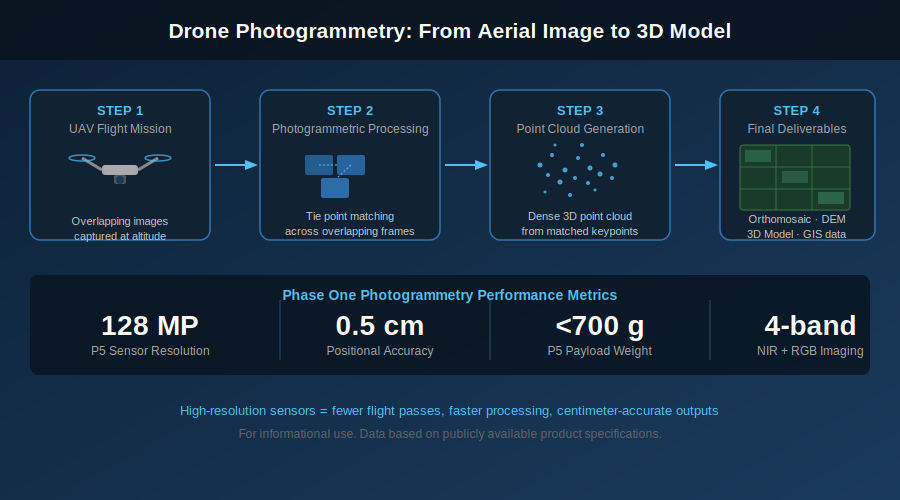
Phase One has built its geospatial imaging line around the specific performance requirements of precision photogrammetry. The company’s iXM camera series — offered in 100MP and 280MP configurations — is designed to deliver the combination of high pixel count, geometric accuracy, and low distortion that aerial mapping demands.
The Phase One mapping and surveying solutions also support 4-band imaging, combining near-infrared (NIR) and visible RGB channels in a single pass. This capability is particularly valuable for agricultural surveys, where normalized difference vegetation indices (NDVI) derived from 4-band imagery can detect early signs of crop stress, disease, or irrigation failure long before they are visible to the naked eye.
For urban and infrastructure mapping, Phase One has documented case studies such as the digitization of Novi Sad, Serbia — where a hybrid system combining two 100MP Phase One cameras with a LiDAR scanner enabled the creation of a comprehensive geographic information system (GIS) of the city’s urban green areas. Projects of this complexity require both imaging precision and processing efficiency that only professional-grade systems can consistently provide.
Photogrammetry Mapping: From Flight to Final Deliverable
A successful drone photogrammetry project depends on performance at every stage of the workflow. Here is how professional-grade imaging systems contribute at each step:
- Mission planning: High-resolution sensors allow operators to fly at greater altitudes while maintaining ground sampling distance (GSD) targets, covering more area per flight.
- Image capture: Global shutters — as featured in the Phase One P5 — eliminate rolling shutter distortion at high flight speeds, ensuring geometric accuracy in the raw imagery.
- Tie point matching: More pixels mean more feature-rich images, which photogrammetric software can match with greater precision.
- Output generation: Final deliverables including orthomosaics, DEMs, and 3D models benefit from the additional detail in source imagery, particularly in areas with low texture or repetitive patterns.
The P5: A Compact System for Precision Corridor and Land Surveys
Phase One’s P5 Engineering Survey Camera represents a notable advance for smaller UAV operators who require professional-grade accuracy without the payload demands of larger systems. Weighing under 700 grams, the P5 integrates a 128MP sensor with a global shutter and achieves positional accuracy of 0.5 cm.
Its support for MAVLink and Auterion protocols makes it compatible with the growing ecosystem of open-source autopilot systems used by commercial survey operators. The P5 is particularly well-suited to corridor mapping applications such as road and railway surveys, pipeline routing assessments, and coastal erosion monitoring — missions where compact integration is as important as data quality.
Drone Photogrammetry vs. Traditional Methods: A Practical Comparison
The advantages of drone-based photogrammetry over traditional surveying methods are well established in the literature. However, the magnitude of these advantages depends heavily on the imaging technology deployed. The following comparison reflects performance achievable with professional-grade UAV cameras:
- Speed: UAV surveys of large areas can be completed in hours rather than days, with data ready for processing the same day.
- Safety: Drone mapping eliminates the need for ground crews to access hazardous terrain, road-adjacent work zones, or structurally compromised sites.
- Repeatability: Systematic UAV surveys using consistent camera systems and flight parameters produce data that can be reliably compared across time periods.
- Cost: While the upfront cost of professional UAV imaging systems is significant, the reduction in field labor, vehicle deployment, and survey duration typically results in lower total project costs for medium-to-large survey areas.
For authoritative technical guidance on drone photogrammetry standards, the International Society for Photogrammetry and Remote Sensing (ISPRS) maintains a comprehensive library of peer-reviewed research at isprs.org, covering accuracy benchmarks, sensor calibration methodologies, and processing pipeline best practices.
Aircraft and Drone Systems: Scaling Up When the Mission Demands It
While compact UAV systems address a wide range of mapping missions, large-area national surveys, offshore infrastructure inspections, and high-altitude terrain mapping often require manned aircraft camera systems capable of carrying multiple sensor payloads simultaneously. Phase One’s aircraft-mounted solutions support configurations of up to six medium-format cameras, achieving combined sensor arrays of up to 880MP.
This scalability — from a 700g compact UAV payload to a multi-camera aircraft system — reflects Phase One’s position as a comprehensive imaging partner for geospatial professionals at every scale.
Conclusion: The Future of Drone Photogrammetry Is Resolution-Driven
Drone photogrammetry is no longer an emerging technology — it is a standard component of professional surveying, infrastructure management, and precision agriculture workflows. As demand for centimeter-accurate geospatial data continues to grow, the imaging systems that underpin these workflows will face increasingly stringent quality requirements.
Phase One’s investment in medium-format sensor technology, geometric accuracy, and workflow integration positions its aerial imaging systems as the benchmark against which other solutions are measured. For organizations whose operations depend on reliable, high-resolution photogrammetric data, selecting the right drone camera is not a peripheral decision — it is foundational to mission success.

The debate between medium format and full frame cameras has intensified as full-frame sensors have become increasingly capable. Today’s top full-frame cameras offer 60MP, 14-stop dynamic range, and ISO performance that would have seemed extraordinary a decade ago. So is medium format still worth the investment?
For photographers working in commercial still life, architecture, beauty, and fine art — where the output will be scrutinized at large reproduction sizes or by trained editorial eyes — the answer is yes, and the reasons are more nuanced than a simple megapixel comparison. This article explains the technical differences that make medium format cameras the choice of demanding professionals, and the specific applications where those differences are most visible.

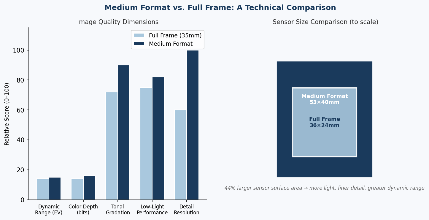
Figure 1: Medium format vs. full frame — image quality dimension comparison and sensor size difference to scale. The 44% larger sensor surface translates directly to improved dynamic range, color depth, and tonal gradation.
The Physics of Sensor Size: Why It Matters
The fundamental advantage of a larger sensor is photon collection. A medium-format sensor — typically 53×40mm versus the 36×24mm full-frame standard — has approximately 44% more surface area. With equal pixel pitch, that larger surface collects more light per exposure, translating to:
- Greater dynamic range: The ability to capture detail simultaneously in deep shadows and bright highlights.
- Lower base ISO noise: Less amplification needed to reach a usable exposure.
- Smoother tonal gradations: More discrete tonal steps between pure white and pure black.
- Richer color depth: More bit-depth per color channel, enabling finer color distinctions in post-processing.
These advantages compound in practical use. A studio fashion photographer working with both shadow detail in dark fabric and highlight retention in bright backgrounds benefits from every extra stop of dynamic range. A still life photographer spending hours on a single setup — where the final image may be reproduced at billboard scale — notices the difference in micro-contrast and tonal smoothness that a medium-format sensor delivers.
Medium Format vs. Full Frame: A Technical Comparison
| Image Quality Dimension | Full Frame (35mm) | Medium Format | Practical Impact |
|---|---|---|---|
| Sensor size | 36×24mm | 53×40mm (typical) | 44% more surface area |
| Max resolution | Up to ~61MP | Up to 150MP | More detail at large print sizes |
| Dynamic range | ~13–14 EV | ~15 EV+ | 1–2 extra stops of DR |
| Color bit depth | 14-bit RAW | 16-bit RAW | 4× more tonal steps per channel |
| Pixel size (typical) | ~4–7µm | ~5–6µm at 100MP | Larger pixels = better per-pixel IQ |
| Crop factor | 1× (reference) | ~0.8× (slight enlargement) | Shallower DoF at equivalent FoV |
The Digital Back Advantage: Modularity and Longevity
One of the structural advantages of medium-format systems built around modular digital backs is the ability to upgrade the sensor without replacing the entire camera system. The Phase One IQ4 digital back attaches to Phase One XF and XT camera bodies, and can also be mounted on a range of technical cameras and view cameras via adapters.
For commercial photographers with significant investments in camera bodies, lenses, and accessories, the modular approach means sensor technology can advance — from 100MP to 150MP, or from a conventional Bayer sensor to a trichromatic or achromatic variant — without retiring the rest of the system.
Trichromatic and Achromatic Sensors: Beyond Standard Color
Phase One’s medium-format lineup includes two specialist sensor variants that have no full-frame equivalent:
Trichromatic sensor: Designed for maximum color accuracy, the trichromatic sensor uses a modified color filter array with narrower, better-separated color band peaks. The result is more accurate color rendering straight from RAW — particularly in skin tones, textiles, and fine art reproduction where color fidelity is the primary deliverable.
Achromatic sensor: The IQ4 150MP Achromatic is a monochrome sensor with no color filter array — delivering maximum resolution, maximum sensitivity, and a tonal rendering that is simply not achievable with a conventional Bayer sensor. Used by architectural photographers, fine art black-and-white practitioners, and scientific imaging specialists.
Bespoke Photography: Where Medium Format Is the Standard
In high-end commercial photography — product, beauty, fashion, food, and architectural work — the medium format system has become the studio standard precisely because the technical quality ceiling is high enough that no client brief exceeds it. The Phase One XF IQ4 camera system is designed for exactly this environment: studio-ready, tethered shooting with a direct pipeline into Capture One software for real-time image review and color grading.
For advertising and editorial commissions where the final image may be reproduced at poster, billboard, or high-resolution screen sizes, the 150MP sensor delivers file sizes with enough data that creative retouching, cropping, and output scaling do not compromise the final result.
Lens System: The Other Half of the Equation
A medium-format sensor is only as good as the optics in front of it. Phase One’s lens lineup for the XF system includes a range of focal lengths from 23mm to 150mm, all designed and optimized for the large image circle of the medium-format sensor. These are not adapted full-frame lenses; they are purpose-built for the sensor and deliver consistent sharpness from edge to edge — a requirement that is particularly visible at 100MP+ resolution where full-frame lens coverage limitations become apparent.
Is Medium Format Right for You?
Medium format is the right choice when:
- Output will be reproduced at large scale (print or screen) where pixel-level sharpness and tonal quality are visible
- Color accuracy is a primary deliverable — fashion, fine art reproduction, product photography
- Monochrome quality is paramount — achromatic sensors deliver results unmatched by any other format
- Tethered studio workflows benefit from the integration between camera and editing software
- Longevity of the system investment is important — modular digital backs allow sensor upgrades
For a comprehensive overview of medium format digital camera options and technical specifications, alltechnews.medium.com provides independent analysis of professional camera systems and imaging technology.
Conclusion
Medium format cameras remain the benchmark for professional studio and commercial photography not out of tradition, but because the physics of a larger sensor continue to deliver measurable, visible differences in dynamic range, color depth, and tonal rendering. The gap has narrowed, but it has not closed.
For photographers whose clients demand the absolute best — and whose work will be evaluated frame by frame, tone by tone — the Phase One IQ4 digital back system represents the current state of the art in digital capture.
Photography
An Overview of Aerial 3D Mapping
3D mapping has plenty of applications in the modern world. One of these is 3D city modeling. City authorities can derive many benefits from volumetric models of their cities, such as creating 3D maps for emergency response and disaster management purposes. That’s not all though! In this article, you’ll learn more about aerial 3d mapping, how it differs from traditional mapping, and some of the benefits that it offers to businesses across the board!
Three-dimensional media has been a hot topic in the last decade. Starting with 3D movies, people have been developing an appetite for experiencing media in 3D. And technology has been evolving to cater for those appetites.
The creation of 3D media has advanced a great deal. In the past, it was out of the reach of most individuals and a good portion of organizations. Now, 3D scanners have become commonplace, and everyone with a few hundred dollars can create a 3D representation of a wide array of items.
But there’s perhaps an even more interesting aspect of 3D media that has been growing rapidly – 3D mapping.
It’s done from the air, there’s really no other way to do it.
In this article, I’ll discuss the essential aspects of aerial 3D mapping and answer the most frequently asked questions.
What is Aerial Mapping?
Understanding aerial mapping is crucial to understanding 3D mapping. They’re actually the same thing, more or less, but the term aerial mapping seems less daunting.
In the most basic sense, aerial mapping is making maps while in the air. But how do you do that?
You need two things: A sensor and an aerial vehicle.
The sensor captures photographs, preferably in high resolution. And the aerial vehicle carries the payload that houses the sensor.
An aerial vehicle can be as small as a drone or as big as an airplane. Your choice of vehicle typically depends on the extensiveness of the area you want to map, as well as constraints such as time and cost.
Once you are in the air with your aerial vehicle and sensor, you capture the sort of images you want.
According to orientation, there are two major types of aerial images: nadir and oblique images.
Nadir images are taken when the sensor is at a ninety-degree angle with the ground. They capture less detail about the vertical aspects of physical features and are not much help in 3D applications like 3D city modeling.
Oblique images are taken when the sensor is at an angle less than 90 degrees with the ground. It’s very useful when taking 3D images of landscapes, such as in 3D city modeling.
For the best results when mapping, the two types of images are usually combined.
Because you want to create a 3D map, the images you take have to overlap. You can control the overlap settings with the help of special software.
After the photos are taken, they’ll be processed and stitched together according to the principles of photogrammetry. The result is that 2D photos are transmitted into a 3D map.
How to 3D Map With a Drone
To 3D map with a drone, you need a drone that is suitably-equipped.
First, it would be best to use professional sensors. This helps obtain high-quality imagery, which makes it easy to easily produce high-quality maps.
Using a professional sensor means that you can’t rely on the sensor that comes with most drones. You’ll have to attach a payload to a drone. With this in mind, you have to obtain a drone that can carry the required payload.
All you need to do is mount your payload on the drone, capture the images, and process them with specialized software to come up with your 3D map.
What is 3D Mapping Used For?
3D mapping has a variety of applications across industries.
One of the applications is 3D city modeling. City authorities can draw multiple benefits from developing volumetric models of their cities. These include design, planning, and population estimation.
With a 3D map, a city can estimate its population by analyzing the volume of buildings.
Such volume analysis is also important in other industries. For example, factories that use large quantities of material can use 3D maps to calculate the volume of remaining material, which helps plan more accurately.
Another use of 3D mapping is the analysis of landscape change. Analyzing how an area has changed over time can help determine the effect of earth movements and detect any risks.
The growth of an area can be analyzed using the same technique. As populations shift and more structures are constructed, the changes can be studied through volumetric analysis.
Photography
Do You Need a Medium Format Camera?
Medium format digital camera are usually made for people who want to take photos of lengths of 100 millimeters or longer. A medium format digital camera has a very wide angle. They are more suited for nature and landscape photography than portrait shots.
Image sensing technology is forever improving. At the moment, it’s possible to use a 280MP camera like the Pas 280 to capture images with extremely high resolution.
But that’s a large format camera. Medium format cameras like the phase one 100mp camera make more sense. They are more affordable and still offer high resolutions of up to 100MP. Still, they are expensive (to the tune of thousands of dollars) leading to the question: Why would you need one?
You need a medium format camera when it is imperative to capture images with impeccable detail, like in advertising and fashion photography. Another perfect application is aerial photography for purposes like inspection, mapping, and surveying, especially when using drones.
When capturing aerial imagery with larger aircraft, you’ll need to use large format cameras like the Pas 280 if you are to take crisp photos with resolutions that make use cases like mapping easy.
In this article, I’ll discuss the factors that necessitate a medium format camera, in addition to the benefits you get from using one.
What Makes a Medium Format Camera Special?
Medium format cameras are expensive. That price tag has to come with unique features, and it does.
To begin with, the level of detail you get from a medium format camera is unbelievable, especially in a studio setting. You can see the most minute details of whatever you capture.
Medium format cameras capture such high detail because they have high-resolution sensors. The advanced sensor comes in handy in the field, for example in landscape photography.
However, it also comes in handy in another fast-emerging area, drone photography.
Drone Photography
While medium format cameras like the Phase One 100MP camera come in handy in the studio and in several field uses, one of their most common uses is in drone photography. In fact, the Phase One 100MP camera can be more aptly referred to as the Phase One drone camera.
Industrial drone photography typically requires extremely high resolution images. If you are taking drone photos to inspect an oil rig, you’ll want the ability to assess millimeter-sized damage to inform preventive maintenance. Similarly, if you are trying to map a city, you’ll want high-resolution images, which will ease the process of stitching the images together to come up with a three-dimensional map.
And since the distinguishing quality of the Phase One drone camera is its impressive detail, it’s perfectly suited for such drone photography use cases.
If you’re using a drone to inspect, map, or survey; you’ll definitely need a medium format camera. Using other cameras with lower resolutions will make your work difficult. You might not even be able to accomplish your goals.
The Disadvantages of Medium Format Cameras
The biggest disadvantage of a medium format camera is the cost. The low-end devices in this category cost a few thousand dollars, which is already expensive. And if you want to enjoy the full power of a medium format device, you’d be better going for the high-end ones, which can cost as much as fifty thousand dollars.
Another con of this class of cameras is the size. A medium format camera with best-in-class features will be large and relatively bulky. Due to this, you may be unable to use it as a hand-held camera.
If you are used to speed, then a medium format camera may feel slow. Many things will be slower, from the autofocus feature to the time taken to load the film.
Also, most medium format cameras are best suited for stills. You can’t use them to shoot video. Even the ones that allow you to shoot video do a shoddy job. You should keep this in mind when acquiring one.
Conclusion
The most important considerations to make when it comes to the medium format camera have to do with price and the level of detail you need in your photos.
The hallmark of this format is detail. They typically have extremely high-resolution, allowing you to capture images with impressive levels of detail.
But you’ll have to part with a lot of money for the best medium format digital cameras.
If your use case involves the regular capture of high-resolution images, then it should be a worthwhile investment. Most industrial applications fall under this category, like the inspection of critical infrastructure.

Targeted Vertical Incubation: Strategic Alignment in Technical Software Venture Co-Investments

The Critical Technical SEO Audit Checklist for Enterprise SaaS Environments

Shadow AI Detection: Regaining Visibility Over Unsanctioned Enterprise Tooling

-

 Business Solutions2 years ago
Live Video Broadcasting with Bonded Transmission Technology
-

 Business Solutions1 year ago
The Future of Healthcare SMS and RCS Messaging
-

 Business Solutions2 years ago
2-Way Texting Solutions from Company Message Services
-
 Business Solutions2 years ago
Communication with Analog to Fiber Converters & RF Link Budgets
-

 DSRC Communication1 year ago
The Crossroads of Connectivity: DSRC vs. C-V2X Technologies in Automotive Communication
-
Electronics3 years ago
AI Modules and Smart Home Chips: Future of Home Automation
-

 Business Solutions2 years ago
Wholesale SMS Platforms with OTP Services
-
 Business Solutions2 years ago
Aerial Wind Turbine Inspection with Advanced Camera Drones