Tech
How to Choose a Camera for Drone Surveying and Mapping

| Key Takeaways
• A camera for drone surveying needs a calibrated lens and sensor, accurate exposure timestamps and a shutter that does not distort images on a moving aircraft. • A global shutter exposes every pixel at once, avoiding the skew that rolling shutters create when a drone is moving. • Ground sample distance scales linearly with altitude; one 128MP payload is specified at 0.26 cm per pixel at 60 m and 0.52 cm per pixel at 120 m. • Because US Part 107 caps routine drone flights at 400 feet above ground, coverage gains have to come from sensor resolution and field of view rather than altitude. |
What makes a camera for drone surveying different from a consumer drone camera?
A camera for drone surveying is built to produce measurable data, which means a calibrated lens and sensor, an accurate exposure timestamp and a shutter that does not distort the image while the aircraft is moving. A consumer drone camera is built for video and attractive stills, and its small sensor, fixed lens and rolling readout are perfectly adequate for that job. For photogrammetry, corridor mapping or engineering-grade surveys, those same traits introduce errors that processing software then has to correct, or cannot correct at all.
Professional drone camera payloads built for survey and inspection are therefore sold as instruments rather than accessories. They typically come with a factory calibration, mount to specific aircraft through standard mechanical and data interfaces, and are rated against accuracy targets rather than just pixel counts.
Which specifications matter most when choosing a camera for drone mapping?
The specifications that matter most are sensor resolution and pixel size, shutter type, lens field of view, metric calibration, weight and how the camera talks to the drone. Each one feeds directly into how much ground a flight covers, how accurate the output is and whether the payload is practical on the aircraft the team already flies.
| Specification | What it controls | What to look for |
| Resolution and pixel size | Ground sample distance and coverage per photo | Higher pixel counts cover more ground at the same GSD |
| Shutter type | Geometric distortion on a moving aircraft | Global shutter avoids rolling-shutter skew |
| Lens field of view | Footprint width versus detail | Interchangeable focal lengths for different missions |
| Metric calibration | Systematic error in the final model | Factory calibration with a certificate |
| Weight | Flight time and platform compatibility | Light enough for the target airframe |
| Integration | Triggering, timestamps and control | Standard protocols such as MAVLink |
The P5, a 128MP survey payload designed for compact drones, illustrates how these factors come together in practice. It pairs a 128-megapixel medium format CMOS sensor with an electronic global shutter, offers 35 mm and 80 mm lens options, weighs under 700 grams and is factory metrically calibrated, with a calibration certificate supplied with each unit.
Why does a global shutter matter for drone surveying?
A global shutter exposes every pixel at the same instant, so a fast-moving drone produces an image with correct geometry instead of the skew a rolling shutter creates when it reads the sensor line by line. Early drone survey workflows sometimes worked around rolling-shutter distortion by slowing down or pausing for each photo. A global shutter removes that constraint, so the aircraft can hold a steady survey speed and the processing software does not have to model and remove a time-varying distortion in every frame.
The timestamp matters just as much as the shutter. Mid-exposure triggering records the moment at the center of each exposure, which lets GNSS positions be matched to images precisely. On a fixed-wing drone flying at well over 15 m/s, even a small timing offset translates into a positional error on the ground.
How does flight altitude affect ground sample distance?
Ground sample distance scales directly with altitude: double the height above ground and each pixel covers twice the distance, for the same lens and sensor. For the 128MP payload above, the published figures are 0.26 cm per pixel at 60 m and 0.52 cm per pixel at 120 m with the 80 mm lens, a near-perfect linear relationship that makes mission planning straightforward.
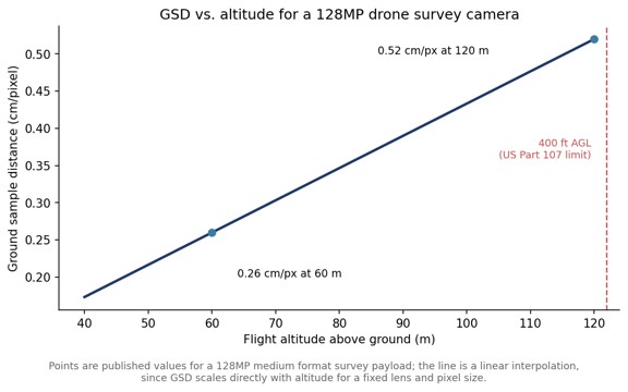

Altitude, however, is not a free variable. In the United States, the FAA’s Part 107 rules cap routine small-drone operations at 400 feet above ground level, roughly 122 m, require the aircraft to stay within visual line of sight unless a waiver is granted and apply to drones under 55 pounds. Because altitude is capped, a camera for drone mapping has to get its coverage from resolution and field of view rather than from flying higher. That is the core argument for medium format sensors on drones: more pixels across the frame means a wider footprint at the same legal altitude and the same GSD.
How much area can a high-resolution drone camera cover in one flight?
Coverage depends on GSD, overlap and the drone’s endurance, but higher-resolution cameras consistently cover more area per flight at a given GSD because each image is wider on the ground. Published figures for the 128MP payload list about 67 hectares at 60 m and about 135 hectares at 120 m, both at 70% overlap, which shows how coverage roughly doubles when altitude, and therefore GSD, doubles.
Pairing a lightweight high-resolution payload with a fixed-wing VTOL airframe extends this further, because fixed-wing aircraft fly longer and faster than multirotors while still taking off and landing vertically. The combination suits long corridors such as roads, pipelines and rail lines, as well as large construction sites where repeated surveys track progress over time.
How accurate can drone survey data be?
With a metric-calibrated camera, accurate timestamps and good ground control or GNSS correction, drone photogrammetry can reach sub-centimeter horizontal accuracy and around one centimeter vertically. For the 128MP payload discussed here, the stated absolute accuracy reaches 0.3 cm RMS horizontally and 0.8 cm RMS vertically. Figures like these always depend on the full workflow, including ground control, flight overlap and processing, so they are best read as what the camera makes possible rather than what every project will achieve.
Integration is the last practical check. A payload that supports industry-standard protocols such as MAVLink and Auterion, and that is already supported in common photogrammetry software, removes most of the custom engineering that otherwise sits between buying a camera and flying a production survey.
Which drone platforms suit a medium format survey camera?
Medium format survey cameras suit drones that can carry around 700 grams of payload with enough endurance to make use of the wider footprint, which in practice means larger multirotors and fixed-wing VTOL aircraft. Mounting flexibility matters here: the same payload may need to point straight down for area mapping or be configured for linear corridor surveys along roads and utilities.
Data handling is the other platform consideration. A 128MP camera producing several frames per second generates large files quickly, so onboard storage, here CFexpress cards of up to 2 TB, and a fast data interface, here 1 gigabit, determine whether a long mission can be flown without stopping to offload images. Checking these figures against planned flight durations avoids discovering a storage limit halfway through a corridor.
Frequently Asked Questions
What is the best type of camera for drone mapping?
For survey-grade drone mapping, a metric-calibrated camera with a large high-resolution sensor and a global shutter is generally preferred, because it produces accurate, distortion-free images at practical flight altitudes.
Does a drone camera need a global shutter for photogrammetry?
A global shutter is not strictly required, but it avoids the rolling-shutter skew that occurs when a moving drone captures an image line by line, which improves geometric accuracy and simplifies processing.
How high can a survey drone fly in the United States?
Under FAA Part 107, small drones are limited to 400 feet above ground level, or higher only when staying within 400 feet of a structure, unless a waiver applies.
How heavy is a medium format drone survey camera?
Medium format drone survey cameras have become light enough for compact drones; one 128MP survey payload, for example, weighs under 700 grams.