Tech
Mapping Cameras: What Aerial Mapping and Aerial Imaging Actually Require

Key Takeaways
|
What makes a mapping camera different from an ordinary aerial camera?
Any camera pointed at the ground from an aircraft captures an aerial photograph, but a mapping camera is engineered around a stricter requirement: the resulting image has to support accurate measurement, not just visual interpretation. Phase One’s aerial mapping and surveying cameras are built around this principle, offering precision aerial 2D and 3D mapping designed to simplify aerial survey and mapping workflows while capturing high-resolution images that support reliable photogrammetry. That precision comes from metric calibration, a design that keeps geometric distortion low enough that a pixel’s position in the image can be trusted to correspond accurately to a real position on the ground.
What does aerial mapping actually require beyond the camera itself?
A mapping camera is only one piece of a functioning aerial mapping system. Turning captured images into usable maps and 3D models depends on knowing exactly where the aircraft was, and how the camera was oriented, at the precise instant each image was captured.
| Component | What it contributes |
|---|---|
| Mapping camera | Captures high-resolution imagery with metric calibration and minimal geometric distortion. |
| GNSS-inertial positioning | Records the aircraft’s precise position and orientation at the moment of capture, tying each image to real-world coordinates. |
| Flight planning software | Generates flight lines automatically and helps control mission costs before the aircraft ever takes off. |
| In-flight review software | Allows a crew to review captured imagery and replan a mission while still airborne, rather than discovering gaps after landing. |
How is aerial mapping actually used in practice?
Real-world aerial mapping deployments span a wide range of scales and purposes. One documented mapping project used a hybrid aerial system combining two 100-megapixel mapping cameras with a LiDAR scanner to digitize an entire city and build a geographic information system (GIS) of its urban green areas. In another case, a 100-megapixel aerial camera served as a key component of a NASA remote sensing system used to study forest regrowth after hurricane-driven deforestation, producing the RGB photography needed to identify fine-scale canopy features. A separate aerial photogrammetry project used a mapping camera paired with an avionic stabilization system to capture data for a hydroelectric reservoir, generating digital elevation models and orthophotos for the site.
Why is demand for aerial imaging climbing so steadily?
The scale of adoption behind these kinds of projects keeps growing. IMARC Group’s aerial imaging market research values the global market at $3.35 billion in 2025, projected to reach $9.06 billion by 2034, a compound annual growth rate of 11.35%. The report attributes much of that growth to rising UAV and drone adoption across agriculture, defense, and infrastructure, alongside advances in LiDAR and multispectral sensors and AI-powered analytics, with UAVs and drones already accounting for over half of the aircraft-type segment as of 2025.
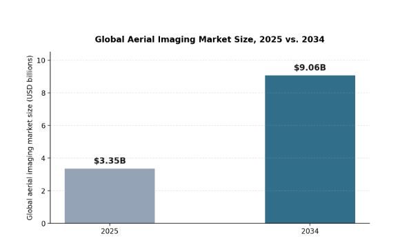

Global aerial imaging market size, 2025 versus 2034, according to IMARC Group.
What industries actually rely on aerial imaging and mapping cameras?
- Urban planning and infrastructure, using high-resolution mapping to track development, plan utilities, and maintain accurate city-scale GIS data.
- Agriculture and forestry, combining mapping-grade imagery with multispectral data to monitor crop health and forest canopy conditions.
- Environmental monitoring and disaster management, capturing before-and-after imagery to assess damage and track environmental change over time.
- Energy and utilities, mapping reservoirs, transmission corridors, and generation sites where accurate elevation models matter for planning and safety.
How does flight altitude affect the resolution a mapping camera can deliver?
Ground sample distance (GSD), the real-world size a single pixel represents on the ground, is the practical measure that connects a mapping camera’s sensor to a mission’s actual requirements. Flying higher covers more ground per flight line, reducing the number of passes needed to survey a given area, but it coarsens GSD and therefore the finest detail the resulting imagery can resolve. Flying lower sharpens GSD considerably but multiplies the number of flight lines, and therefore flight time, needed to cover the same total area. A mapping camera with higher native resolution gives a mission more flexibility in this tradeoff, since it can fly higher while still achieving the GSD a project actually requires, rather than being forced to fly low and slow to hit the same target resolution.
| Mission type | Typical altitude and GSD priority |
|---|---|
| Large-area regional mapping | Higher altitude, coarser GSD, prioritizing coverage efficiency over fine detail. |
| Urban and infrastructure mapping | Moderate altitude, balancing coverage with the resolution needed to resolve individual structures. |
| Precision agriculture and forestry | Lower altitude or drone-based capture, prioritizing GSD fine enough to resolve individual plants or canopy features. |
| Engineering-grade survey and inspection | Lowest practical altitude, prioritizing maximum achievable resolution over coverage speed. |
What should a project weigh when specifying a mapping camera system?
- Required ground sample distance: the finest detail the project actually needs to resolve, which drives both camera resolution and flight altitude decisions together.
- Total area and timeline: larger areas under tighter deadlines favor higher-resolution sensors that can fly higher without sacrificing required detail.
- Positioning accuracy requirements: engineering-grade survey work typically demands tighter GNSS-inertial accuracy than general land-cover mapping.
- Whether multispectral data is needed: agriculture, forestry, and environmental projects often require NIR capture alongside standard RGB imagery.
Frequently Asked Questions
Can any high-resolution camera be used for aerial mapping?
Resolution alone isn’t sufficient. A mapping camera needs metric calibration and low geometric distortion so that pixel positions can be reliably translated into real-world coordinates, which a general-purpose high-resolution camera isn’t necessarily built to guarantee.
What’s the difference between 2D and 3D aerial mapping?
2D mapping typically produces an orthomosaic, a flat, geometrically corrected image of the surveyed area. 3D mapping goes further, using overlapping imagery (and often LiDAR) to reconstruct elevation and structure, producing digital elevation models or full 3D reconstructions.
Why does aerial mapping need GNSS-inertial positioning if the camera is already accurate?
A camera’s own accuracy only describes how faithfully it records what it sees. Without precise position and orientation data for the aircraft at the moment of capture, there’s no reliable way to tie that image to an exact location on the ground.
Does multispectral capability matter for general aerial mapping, or only agriculture?
It matters most directly for agriculture, forestry, and environmental monitoring, where near-infrared data reveals vegetation health that visible-light imagery alone can’t show. General infrastructure and urban mapping projects can often rely on standard RGB imagery alone.