Tech
High-Resolution Photogrammetry in Aerial Mapping: Optimizing Spatial Data Accuracy and Flight Efficiency

High-resolution photogrammetry technology resolves the severe operational bottlenecks that traditional imaging hardware can no longer handle within modern engineering and geospatial surveying sectors. A single infrastructure corridor inspection or topographic survey routinely covers thousands of hectares of varying terrain. Furthermore, standard environmental surveying projects regularly demand hundreds of parallel flight passes, a requirement that generates massive quantities of fragmented data. Industrial utility corridors—such as pipelines, railway networks, and power grids—require continuous, high-altitude monitoring. In these scenarios, any reduction in image sharpness leads to geometric errors during post-processing. Consequently, the sheer volume of raw data captures stretches engineering workflows to their limits, while an inaccurate point cloud reconstruction can cause severe structural design failures or costly project delays.
Dedicated metric imaging systems have emerged as the definitive structural response to these geospatial challenges. By engineering metrically calibrated, large-format and medium-format sensors explicitly for flight payloads, modern setups automatically minimize lens distortion, optimize spatial resolution, and maximize coverage area per flight line. Therefore, this structural integration drastically reduces the physical demands placed on flight crews and processing teams while simultaneously enhancing the absolute accuracy of the final topographic models. This review evaluates how high-resolution aerial imaging functions, why it has become the benchmark for commercial surveying operations, and what optical mechanics distinguish dedicated metric systems from standard commercial drone cameras.
What Is High-Resolution Aerial Photogrammetry?
High-resolution aerial photogrammetry involves the automated collection and processing of overlapping aerial images to calculate precise three-dimensional coordinates of physical objects on the Earth’s surface. Unlike generic consumer-grade photography or basic video mapping, specialized metric data collection relies on sensor platforms constructed specifically to maintain internal geometric stability under intense flight vibrations and wide temperature fluctuations.
Advanced metric platforms distinguish themselves by utilizing sensor dimensions that far exceed standard 35mm formats. These large-format and medium-format configurations allow surveying systems to resolve sub-centimeter Ground Sample Distance (GSD) from significantly higher operating altitudes. Furthermore, integrated global leaf shutter mechanisms eliminate the rolling shutter distortions common in standard drone hardware, ensuring that each pixel is exposed simultaneously and capturing an unwarped image plane even at high cruise velocities.
The Scale of the Aerial Surveying Challenge
The operational dimensions of large-scale mapping projects present major logistical and financial hurdles. In traditional aerial surveying, utilizing standard 24-megapixel or 50-megapixel sensors means that to achieve a high spatial resolution, aircraft must operate at low altitudes and tight line spacings. This configuration increases the total flight lines required to achieve adequate side and forward overlap, which directly translates to extended flight hours, increased fuel expenditure, and prolonged exposure to hazardous weather windows.
This reality exposes a clear operational constraint: lower-resolution payloads degrade surveying profitability by multiplying field capture times and increasing data complexity. High-resolution sensor integration fundamentally shifts this dynamic. By scaling sensor capabilities to 100 megapixels or 150 megapixels, mapping groups can expand their ground swath width substantially, transforming what used to be a multi-day flight operation into a streamlined, single-pass execution.
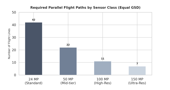
Required Flight Paths by Sensor Class (Equal GSD)
To understand how pixel density translates into operational financial savings, surveying teams must analyze flight path requirements. Increasing sensor resolution directly widens the lateral ground swath covered during a single pass. As a result, the aircraft requires far fewer parallel passes to map a fixed surface area, saving significant flight time and fuel.
The column chart below illustrates how switching to an advanced aerial mapping camera dramatically minimizes total flight line overhead:
Bar chart showing the required parallel flight paths by sensor class to achieve equal Ground Sample Distance, demonstrating that a twenty-four megapixel standard camera requires forty-two lines, while a one hundred and fifty megapixel ultra-res metric camera requires only seven lines.

| Feature / Metric | Standard Commercial Sensors | Specialized Metric Mapping Systems |
| Data Capture Width | Narrow ground swath; requires high line overlap |
Ultra-wide ground swath; maximizes coverage per pass |
| Shutter Architecture | Rolling electronic shutter; prone to movement blur |
Global leaf shutter; eliminates high-speed geometric distortion |
| Calibration Stability | Variable; changes with temperature and vibrations |
Permanently locked metric calibration; verified parameters |
| Altitude Capabilities | Restricted to low altitudes to maintain acceptable GSD |
Capable of high-altitude operations with sub-centimeter GSD |
| Processing Complexity | High volume of images; demands extensive processing time |
Minimal, high-density images; drastically shorter mosaic times |
| Structural Adaptability | Limited to specific consumer drone mounts |
Flexible; optimized for manned aircraft and payload drones |
| Spectral Options | RGB only; requires independent sensor changes |
Seamless co-registered RGB and 4-band imagery options |
Core Metric Camera Capabilities for Geospatial Applications
The following technical attributes represent the baseline criteria for professional-grade imaging integration within modern commercial mapping and surveying applications:
-
Calibrated Metric Optics: Factory-locked lens elements eliminate internal structural shifting, ensuring consistent focal length parameters across thousands of flight cycles.
-
High Dynamic Range (HDR): Advanced pixel architectures preserve fine shadow detailing and highlight definition simultaneously, which is critical when mapping high-contrast environments.
-
Integrated Hardware Synchronization: Microsecond-level integration links the camera shutter, flight management systems (FMS), and onboard GNSS/IMU receivers to provide precise orientation data.
-
Multi-Band Sensor Formats: Systems support simultaneous RGB and Near-Infrared (NIR) data capture to deliver accurate four-band imagery for agricultural and environmental monitoring.
-
Unmatched Shutter Durability: Industrial-grade mechanical leaf shutters survive hundreds of thousands of actuation cycles without requiring frequent maintenance intervals.
Payloads and Platforms: A Critical Architecture Decision
A primary decision point for commercial surveying operations involves choosing between medium-altitude manned aircraft integrations and lightweight UAV payload configurations. Historically, ultra-high-resolution mapping was restricted to large, manned aircraft due to the weight and power requirements of heavy, large-format camera enclosures. While highly efficient for continental-scale mapping, this approach introduces substantial operational overhead, fuel costs, and mobilization delays for regional project work.
The emergence of ultra-lightweight, medium-format 3d mapping camera designs has resolved this operational compromise. Modern 100MP and 150MP architectures have been miniaturized into specialized compact enclosures, allowing them to be deployed as a standard uav camera payload configuration. This engineering milestone brings true large-scale photogrammetry accuracy down to localized drone mapping and surveying workflows, providing an agile, rapidly deployable solution that eliminates manned aircraft costs while preserving metric integrity.
Deployment Environments: Where Specialized Imagery Delivers Value
Industrial metric imaging systems provide the most reliable operational returns in complex environments characterized by strict accuracy requirements and challenging flight windows:
-
Topographic and Cadastral Surveying: Creating highly accurate base maps for land administration, property boundaries, and civil engineering designs.
-
Urban 3D Digital Twin Development: Capturing high-density oblique imagery over dense metropolitan sectors to construct distortion-free 3D city models.
-
Volumetric Open-Pit Mining Analysis: Delivering reliable, repeatable point clouds to calculate stockpile volumes and excavation rates safely from the air.
-
Large-Scale Corridor Mapping: Monitoring linear assets like transcontinental pipelines, highway networks, and electrical transmission grids efficiently.
What to Look for in an Aerial Surveying Platform
Procurement teams and engineering directors evaluating new aerial surveying platforms should rigorously assess lens-to-sensor integration, ensuring the optical elements explicitly match the high-resolution pixel pitches to prevent edge softness. Furthermore, operational weight and power efficiency must fall within the maximum takeoff weight (MTOW) limits of target UAVs to prevent degrading flight times. Software workflow integration must also be assessed to see how seamlessly the native camera software links with post-processing suites to optimize orthophoto generation. Finally, real-world environmental protection should be verified to confirm that the imaging enclosure features an industrial IP rating to withstand high thermal variations encountered during flight. Choosing a platform engineered around physical pixel density and mechanical calibration directly removes the risks associated with unreliable field captures, proving that long-term surveying success is built on optical precision.
Conclusion
High-resolution photogrammetry has established itself as an indispensable core component of modern aerial surveying and geospatial analysis. The combination of massive pixel counts, rigorous geometric calibration, and flexible deployment across drone and aircraft platforms makes metric hardware an essential asset for firms managing tight project windows and strict data criteria. As the global demand for accurate 3D spatial models and real-time digital twins continues to accelerate, the operational gap between consumer-grade camera arrays and highly sophisticated metric platforms will continue to expand—solidifying high-resolution optical solutions as an absolute necessity for competitive geospatial operations.