Business Solutions
Elevating Inspections with Drones and 3D Photography
Drones and 3D photography are revolutionizing inspections, offering unmatched precision, efficiency, and innovation. Discover how this cutting-edge tech transforms the way inspections are conducted.
The Rise of Drone-Based Aerial Inspections
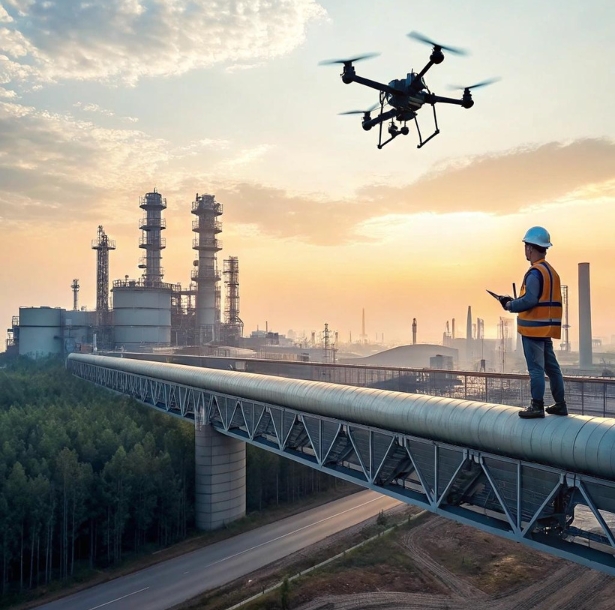
There was a time when inspecting a bridge, a pipeline, or even a cell tower meant dispatching a full team, shutting things down, and sometimes risking safety just to get a closer look. Not anymore. Today, aerial inspections using drone technology are changing the game—delivering fast, accurate results without putting anyone in harm’s way. And with 3D aerial photography added to the mix, it’s not just about getting a look from above; it’s about understanding environments in full spatial detail.
This combination of speed, safety, and rich visual data is exactly why industries like energy, construction, and agriculture are turning to drones. They’re not just a cool tool—they’re becoming essential.
If you haven’t yet explored aerial inspections using drone systems, now’s the time to start. It’s a strategic move, not just a technical one.
What is 3D Aerial Photography?
When we talk about 3D aerial photography, we’re talking about more than just pictures from the sky. It’s about turning those images into layered, measurable, interactive models. Instead of a flat overhead shot, you get depth, perspective, and the ability to virtually “walk” through a scene—just without leaving your desk.
The technology behind it includes photogrammetry (using overlapping photos to build 3D models) or LiDAR (which bounces light to capture elevation data). Either way, the end result is the same: you get incredibly detailed, three-dimensional renderings of terrain, buildings, or infrastructure that are useful across a range of applications.

The Tools Making It Happen
The magic doesn’t come from any off-the-shelf drone. To pull off quality inspections and capture solid 3D imagery, you need the right gear—high-resolution cameras, powerful sensors, and drones that can fly precise routes using GPS.
Some drones even carry thermal sensors or LiDAR units, depending on what the job calls for. And just as important as the drone itself is the software used to plan each flight and process the data afterward. Without proper overlap and flight planning, your 3D model could come out incomplete or inaccurate.
This isn’t just about getting a bird’s-eye view—it’s about gathering precise, measurable data.
Turning Photos into 3D Models
Once the drone has done its job, it’s time to transform raw images into usable 3D models. This happens in specialized software that aligns all those overlapping photos or LiDAR scans and builds out a detailed digital replica.
That process can take some time depending on how much data was collected, but the results are powerful. Whether it’s a point cloud, mesh model, or an orthophoto map, you’re left with a digital asset that can be used for measurements, planning, or progress tracking.
Pro tip: if you want pinpoint accuracy, placing ground control points (GCPs) at the site and calibrating them with GPS will make your final model rock solid.
Rules of the Sky
It’s important to remember that drones don’t fly in a legal vacuum. Every country has its own set of regulations. In the U.S., for instance, commercial drone operators need to pass an FAA Part 107 certification. In other places, there are rules about how high you can fly, how close you can get to buildings or people, and whether you need special insurance.
Skipping this step? Not worth the risk. Staying compliant not only protects your company from fines, but also keeps your operations professional and above board.
Why 3D Aerial Photography is a Game-Changer
So, what’s the big deal about 3D? Imagine being able to measure the height of a tower, the width of a road, or the volume of a stockpile—all from your desk. No need to send a crew on-site, no need to shut things down. That’s what 3D aerial photography brings to the table.
It’s a huge time-saver, and it opens up opportunities for better planning and clearer communication between teams. You can see things from angles that ground teams simply can’t capture. And because everything is georeferenced, what you see is measurable.
Power companies use drones to check transmission lines. Construction firms monitor site progress and check for issues. Cities use 3D mapping for urban planning. Farmers analyze land and crop health. Even emergency services rely on drones for disaster response mapping.
This isn’t emerging tech anymore—it’s mainstream, and it’s only getting more advanced.
A Few Bumps in the Flight Path
As with anything, drone-based inspections and 3D modeling come with a few challenges. Weather is one. Wind, rain, and poor lighting can all mess with your data quality or keep the drone grounded. Battery life is another limitation, though it’s improving with every new generation of hardware.
Processing data takes time and computing power, and managing all those files can get messy if you don’t have a system in place. Plus, you need trained pilots and analysts who know what they’re doing.
Still, these are manageable hurdles—and a small price to pay for what drones deliver.
What’s Coming Next
If you think drone inspections and 3D imagery are impressive now, just wait. AI is starting to play a major role, helping automatically detect cracks, corrosion, or other issues without manual review. And real-time mapping is on the rise—imagine seeing a 3D model being built live as the drone flies.
We’re also seeing longer flight times, smarter sensors, and even drone swarms working together on complex tasks. This technology is evolving fast, and those who stay ahead of the curve will reap the biggest rewards.
Thinking About Getting Started?
If this all sounds exciting but slightly overwhelming, don’t worry—you don’t need to jump into the deep end on day one. Start by figuring out what problems drones could solve for your team. Then look into hardware options, flight planning tools, and what kind of training (or partners) you might need.
Look for drone systems that offer flexibility in terms of payloads and flight options. Choose platforms that can grow with your needs. And make sure you’ve got the right people (or support) to turn all that data into insight.
The combination of aerial inspections using drone systems and the power of 3D aerial photography is transforming how we see, measure, and manage the world around us. It’s faster. It’s safer. And it’s smarter. Whether you’re inspecting infrastructure, planning a construction site, or managing assets over hundreds of miles, drones give you the tools to do it better.
FAQs: Aerial Inspections and 3D Drone Photography
- What are aerial inspections using drones?
Aerial inspections using drones refer to the practice of using unmanned aerial vehicles (UAVs) to capture images, video, and data from above, allowing for safe and efficient inspection of infrastructure, construction sites, power lines, and more without sending people into risky or hard-to-reach environments.
- How does 3D aerial photography work?
3D aerial photography involves capturing multiple overlapping images from different angles during a drone flight, which are then processed using photogrammetry or LiDAR to generate a three-dimensional digital model of the landscape or object.
- What equipment is needed for 3D drone photography?
You’ll need a drone equipped with a high-resolution camera, GPS for geotagging, and sometimes LiDAR or multispectral sensors, depending on the project. Specialized software is also necessary to process the images into 3D models.
- Is drone-based inspection more accurate than traditional methods?
Yes, in many cases it is. Drones can capture high-resolution, georeferenced data and provide access to angles that humans often can’t reach. With proper planning and processing, drone inspections can offer highly accurate and measurable results.
- What industries benefit most from 3D aerial imaging?
Industries like construction, energy, agriculture, mining, public safety, and infrastructure maintenance benefit significantly from 3D aerial photography and drone inspections due to improved data quality, reduced downtime, and enhanced safety.
- Are there legal requirements to fly drones commercially?
Yes. Most countries require drone pilots to be licensed and adhere to aviation regulations. In the U.S., for example, the FAA requires a Part 107 certification for commercial drone operations.
- What are ground control points and why are they important?
Ground control points (GCPs) are physical markers on the ground with known coordinates. They help improve the accuracy of 3D models by aligning drone imagery with real-world geographic data.
- Can drone inspections happen in bad weather?
Not usually. Strong winds, rain, and poor visibility can interfere with both flight performance and data quality. Most professional drone operators wait for stable weather to ensure safe and accurate operations.
- How long does it take to process a 3D model?
Processing time varies depending on the size of the area and the amount of data collected. Simple models may take a few hours, while complex or large-scale sites can require a day or more of processing.
- How can I start using drones for inspections?
Start by identifying the problems you want to solve, then research suitable drone platforms, imaging needs, and flight planning software. It’s also important to either train in-house staff or work with a certified drone services provider.