Software
Drone Imaging vs Drone Inspections: Platforms, Cameras, and Use Cases Compared (2026)

At a Glance
- Drone imaging and drone inspections have emerged as two of the fastest-growing application segments in commercial UAV operations – each requiring different sensor capabilities, flight profiles, and data processing workflows.
- The distinction between a drone imaging platform optimised for mapping and a drone inspection system optimised for close-range asset assessment is significant: camera resolution, lens choice, stabilisation, and lighting all differ substantially between the two use cases.
- Market demand for both applications is accelerating: infrastructure owners, energy operators, telecoms companies, and government agencies are all increasing their drone program budgets as ROI from drone-based data collection becomes well established.
- Phase One’s dual capability – high-resolution mapping cameras for drone imaging missions and precision inspection cameras for asset assessment — makes it the platform vendor of choice for operators who serve both markets.
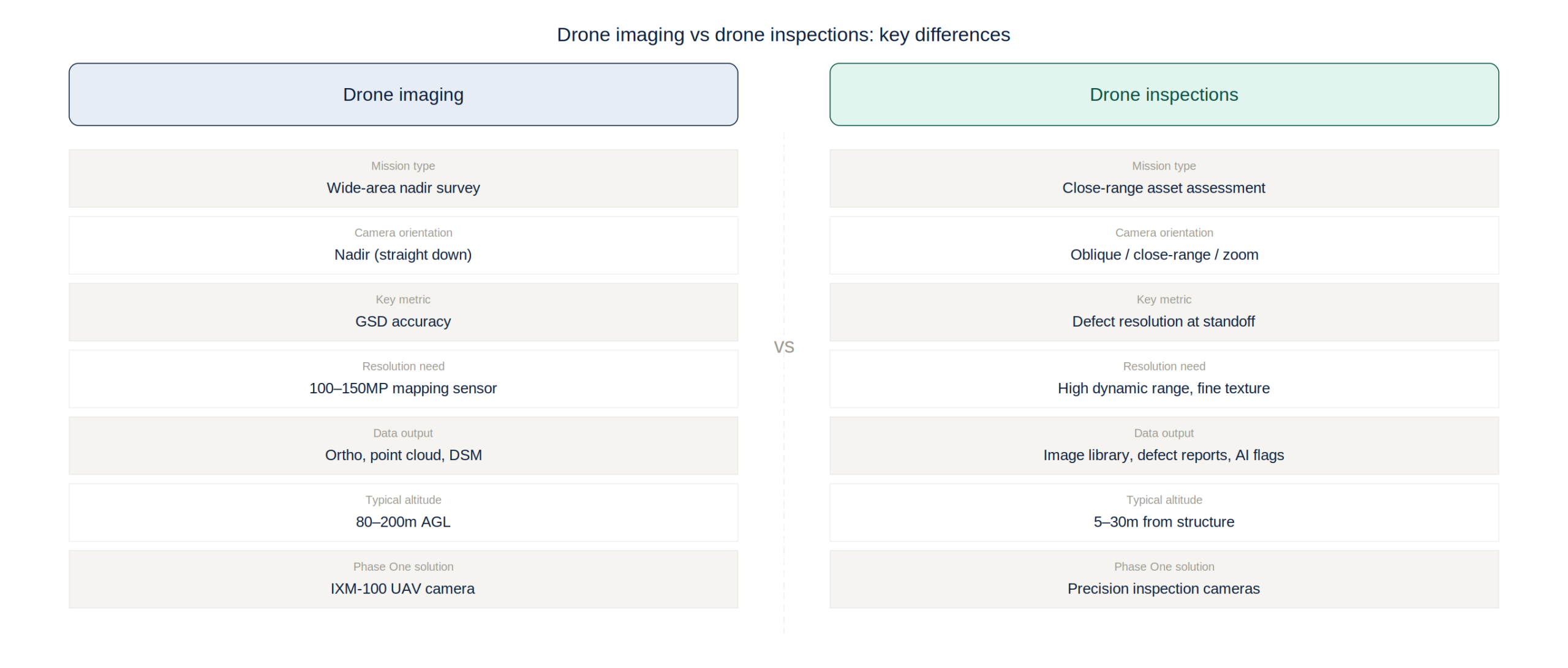
Drones have become the workhorses of commercial geospatial data collection – but the phrase ‘drone operations’ covers a range of applications so diverse that grouping them under a single technology label obscures more than it reveals. Drone imaging for topographic mapping, corridor surveying, and 3D model generation requires fundamentally different hardware, software, and operational protocols than drone inspections of bridges, power lines, wind turbines, and oil and gas infrastructure. Understanding these differences is essential for operators, asset owners, and technology buyers selecting platforms and cameras for specific mission requirements.

Drone Imaging: Mapping, Surveying, and 3D Modelling
Drone imaging for geospatial applications – mapping terrain, producing orthomosaics, generating point clouds, and creating 3D digital twins – requires cameras optimised for nadir (downward-looking) capture with consistent overlap and a wide field of view. The key performance metrics are ground sample distance (GSD), radiometric calibration accuracy, and geometric stability under variable lighting conditions.
Phase One’s IXM-100 and related UAV camera solutions are designed specifically for drone imaging missions requiring sub-5cm GSD and radiometrically calibrated imagery suitable for quantitative analysis. The 100-megapixel sensor captures substantially more detail per frame than the 20-45MP sensors used in consumer and prosumer drone cameras – enabling higher flight altitude for the same GSD, reducing flight time and increasing mission efficiency without sacrificing the resolution that professional deliverables demand.
The commercial drone imaging market includes well-established players such as DJI’s mapping-oriented platforms, Sony’s RX1R II-based solutions, and integrated systems from Micasense and Parrot. Phase One occupies the professional-grade tier of this market, where accuracy requirements exceed consumer drone capabilities and clients have zero tolerance for survey rework caused by inadequate image resolution or unstable sensor geometry.
Drone Inspections: Close-Range Asset Assessment
Drone inspections address a fundamentally different imaging challenge from mapping surveys. Rather than capturing consistent nadir imagery over wide areas, inspection missions require close-range photography of specific asset features – cracks in concrete structures, corrosion on steel components, damage on rotor blades, insulator defects on power lines – where the ability to resolve fine detail at challenging angles and lighting conditions determines whether defects can be identified and characterised accurately.
The sensor requirements for inspection differ accordingly: higher dynamic range to handle the contrast between bright sky and shadowed structure surfaces; zoom capability or interchangeable telephoto lenses for close-up capture from safe standoff distances; and either mechanical stabilisation or gyro-stabilised mounting to maintain image sharpness during proximity flight. For thermal inspection applications – increasingly used for electrical system monitoring, building envelope assessment, and solar panel inspection – thermal sensors with high spatial resolution and accurate temperature measurement are required alongside or instead of RGB cameras.
Leading drone inspection platforms include purpose-built systems from Flyability (confined space inspection), Skydio (autonomous close-range inspection with obstacle avoidance), and DJI’s Dock-based enterprise inspection solutions. Phase One’s inspection camera solutions integrate with these platforms, providing the high-resolution imaging capability that professional inspection workflows demand – particularly for applications where defect documentation must withstand legal and regulatory scrutiny.
Key Differences: Camera Requirements by Application
The camera requirements for drone imaging versus drone inspections diverge significantly across five dimensions. Resolution: drone imaging benefits from maximum pixel count for GSD efficiency; inspection benefits from targeted high resolution at close range with the ability to capture fine texture detail in variable lighting. Lens: mapping uses wide-angle prime lenses for consistent geometric coverage; inspection uses longer focal lengths for standoff distance and portrait-orientation capture of vertical structures.
Processing: mapping data is processed in photogrammetry pipelines (Pix4D, Agisoft, iX Suite) to generate 3D models and orthomosaics; inspection imagery is reviewed frame-by-frame or processed through AI defect detection systems trained on specific asset types. Regulatory: mapping flights typically operate at altitude with automatic collision avoidance; inspection flights often operate at low altitude around structures, requiring specific waiver approvals and manual pilot control. Data volume: mapping missions generate tens of thousands of overlapping images processed as a batch; inspection missions generate targeted image sets structured around specific asset elements and numbered reference points.
Phase One’s portfolio addresses both requirements: the IXM-100 for drone imaging missions requiring maximum GSD efficiency and radiometric accuracy, and precision inspection camera solutions for close-range asset documentation requiring high dynamic range and fine detail resolution.
The ROI Case for Professional Drone Cameras
The business case for investing in professional-grade drone cameras – rather than relying on cameras integrated into consumer drone platforms – is most compelling for operators who serve multiple mission types, maintain repeat client relationships, and face accuracy requirements that consumer cameras cannot reliably meet.
For drone imaging, the accuracy premium of a Phase One IXM-100 system versus a DJI Phantom 4 RTK translates directly into deliverable quality: orthomosaics with sharper feature resolution, point clouds with higher density per flight hour, and digital elevation models with better vertical accuracy. For professional mapping clients – infrastructure owners, government agencies, and engineering firms – these quality differences justify the price premium through reduced survey repeat rates, fewer ground control requirements, and longer useful life of acquired datasets.
For drone inspections, the primary ROI driver is defect detection reliability. A missed defect on a wind turbine blade, a bridge bearing, or a high-voltage insulator can cost orders of magnitude more than the inspection program itself. Professional inspection cameras with sufficient resolution and dynamic range to document marginal defects – those at the limit of detectability – provide an insurance value that dwarfs their acquisition cost when measured against the cost of structural failure or unplanned maintenance.