Photography
Digital Large Format Cameras Explained: Swath, Overlap and What 20,000 Pixels Buy You

| Key Takeaways
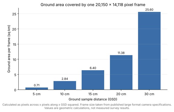
• A digital large format aerial camera records frames more than 20,000 pixels across, so one exposure covers far more ground than a smaller frame format. • At 10 cm GSD, a 20,150 by 14,118 pixel frame covers about 2.84 square kilometers, roughly 2,015 m by 1,412 m. • A 280 MP frame covers nearly twice the ground area of a 150 MP frame at the same GSD, which cuts the number of flight lines needed for a given block. • Dynamic range, capture rate and system weight matter alongside pixel count when matching a large format camera to an aircraft and a project. |
What is a digital large format camera in aerial mapping?
A digital large format camera is a metric aerial frame camera whose single exposure is wide enough to cover a large strip of ground, which in the current 280 MP class means more than 20,000 pixels across the flight line. Because each frame covers more terrain, a survey aircraft needs fewer flight lines and fewer exposures to blanket the same project area. Some designs build the wide frame from more than one sensor: a dual-lens 280 MP metric camera generates a central projection image from two 150 MP nadir images with equal ground resolution, according to trade press coverage of the 280MP launch. The two lenses are 90 mm optics that capture RGB information.
How does frame width translate into ground coverage?
Ground coverage equals pixel count multiplied by ground sample distance (GSD). A frame of 20,150 by 14,118 pixels flown at 10 cm GSD therefore covers about 2,015 m by 1,412 m, or roughly 2.84 square kilometers in one exposure. The same arithmetic scales quickly: doubling the GSD to 20 cm quadruples the area per frame to about 11.4 square kilometers, which is why project planners trade resolution against productivity so deliberately. The calculation matches the frame dimensions published for the complete 280 MP aerial camera system, where the camera is paired with a GNSS/IMU receiver, a gyro-stabilized mount and flight management software, as GPS World’s launch report described.

Why do dynamic range and capture rate matter as much as pixel count?
Pixel count sets how wide a frame is, but dynamic range and capture rate decide how much of the day a crew can actually fly and how much overlap the aircraft can sustain. The sensors in the 280 MP system are backside illuminated CMOS devices with a dynamic range of 83 dB, a figure reported in GIM International’s launch news. The manufacturer’s published specifications for the iXM-RS 280F add that images can be captured every 0.5 seconds, that a forward overlap of 97 percent is achievable at 10 cm GSD at 150 knots, and that motion blur stays under one pixel at up to 390 knots ground speed at 10 cm GSD. Those are vendor-stated figures, so mapping teams should confirm them against their own aircraft, mount and altitude before relying on them.
How do large format cameras compare with smaller frame formats?
A 280 MP large format frame covers nearly twice the ground area of a single 150 MP frame at the same GSD. The table below uses published pixel dimensions for a 150 MP camera of 14,204 by 10,652 pixels and for a 280 MP camera of 20,150 by 14,118 pixels, with ground figures calculated at 10 cm GSD.
| Specification | 150 MP frame | 280 MP large format frame |
| Pixels across and along | 14,204 x 10,652 | 20,150 x 14,118 |
| Ground width at 10 cm GSD | about 1,420 m | about 2,015 m |
| Ground height at 10 cm GSD | about 1,065 m | about 1,412 m |
| Area per frame at 10 cm GSD | about 1.51 sq km | about 2.84 sq km |
| Relative swath width | 1.0x | about 1.4x |
The wider swath means roughly 30 percent fewer flight lines for the same block when overlap is held constant, though real savings depend on terrain, airspace and turn time. A large frame does not remove the need for planning. It raises the stakes of getting GSD, side overlap and aircraft speed right, because each missed frame costs more ground.
Which mapping projects benefit most from large format coverage?
Large format cameras suit small and medium area mapping, corridor mapping, LiDAR mapping, urban mapping and 3D city modeling, the application list given in distributor documentation for the 280 MP class. Corridor and urban work benefit because wide frames reduce the number of strips an aircraft must fly over long, narrow or dense targets. Some configurations add a near-infrared camera to create a 4-band system, which GeoConnexion reports is most useful in agriculture, forestry and pipeline monitoring.
What should a buyer verify before choosing a large format camera?
Buyers should verify four things: the GSD achievable at the aircraft’s practical operating altitude, the overlap the camera can sustain at cruise speed, the compatibility of the mount and positioning hardware, and the calibration documentation supplied with the camera. System weight and size are also decisive for smaller survey aircraft. The 280 MP system published at around 31 kg and 460 by 430 by 440 mm for the standard RGB configuration, which keeps it suitable for a wide range of aircraft, according to its published description. Finally, check how raw files are exported. Standard formats such as TIFF and JPEG keep downstream photogrammetry software choices open, and the 280 MP camera’s published output formats include distortion-free RGB in TIFF or JPEG.
What does a complete large format system include?
A complete large format system includes more than the camera body: it adds a GNSS/IMU receiver for position and orientation, a gyro-stabilized mount, a controller and flight management software. The 280 MP system announced in March 2020 combined the camera with a GNSS/IMU receiver, a gyro-stabilized mount, a controller and flight management software, according to GPS World’s launch report. Mount and positioning hardware affect image quality as directly as the lens does, because a camera that drifts in pitch or roll during an exposure loses geometric consistency from frame to frame. Integrators should therefore evaluate the camera, mount and navigation unit as one package.
How many flight lines does a wider frame actually save?
A wider frame saves flight lines in proportion to the extra swath, minus the side lap needed to tie neighboring strips together. As a simple illustration, assume a 10 km wide block flown at 10 cm GSD with 30 percent side lap. The 280 MP frame advances about 1,410 m between lines (2,015 m x 0.7) and needs about 8 lines, while the 150 MP frame advances about 994 m (1,420 m x 0.7) and needs about 11. That is a saving of roughly three lines on a block this size, before turn time and airspace limits are counted. The figures are geometric estimates, and a real mission plan would also add margin at the block edges and follow the terrain.
Frequently Asked Questions
What does large format mean for a digital aerial camera?
It means a metric frame camera whose images are wide enough, more than 20,000 pixels across in the 280 MP class, to cover a large ground strip in a single exposure.
How much ground does one 280 MP frame cover at 10 cm GSD?
A 20,150 by 14,118 pixel frame covers about 2,015 m by 1,412 m at 10 cm GSD, which is roughly 2.84 square kilometers.
Can a large format aerial camera capture near-infrared imagery?
Yes, some configurations add a near-infrared camera to produce 4-band imagery that records RGB and NIR together, a setup used in agriculture, forestry and pipeline monitoring.
Is a larger frame always better for aerial mapping?
No, a larger frame improves productivity on wide or long projects, but small sites may be served just as well by a smaller frame, and results still depend on correct GSD, overlap and planning.