Industrial Solutions
Aerial Survey Methods and Aerial Mapping Software Compared: 2026 Guide

At a Glance
- Aerial survey is undergoing its most significant transformation in decades – driven by higher-resolution sensor technology, AI-accelerated processing, and the growing demand for sub-centimetre accuracy across infrastructure, urban planning, and environmental monitoring.
- Aerial mapping software has evolved from post-processing pipelines into real-time integrated platforms that manage sensor data, flight planning, georeferencing, and deliverable production in a single workflow.
- The choice of sensor and software defines the accuracy, efficiency, and commercial viability of every aerial survey project – making platform selection a strategic decision, not just a procurement one.
- Phase One’s integrated approach — combining the world’s highest-resolution aerial cameras with the iX Suite software platform – sets the benchmark against which all aerial survey and mapping solutions should be evaluated.
There has never been more demand for accurate, high-resolution aerial survey data — and never more choice in how to acquire it. Government agencies mapping national infrastructure, urban planners building 3D city models, environmental scientists monitoring deforestation, and engineering firms conducting corridor surveys all depend on aerial survey capability that delivers reliable, precise, and rapidly processed geospatial intelligence. The sensor and aerial mapping software combination chosen for these missions determines whether they succeed.

The Aerial Survey Technology Landscape in 2026
Aerial survey is no longer the exclusive domain of manned fixed-wing aircraft carrying large-format film cameras. The market today spans a continuum from consumer-grade drone photogrammetry at one end to precision manned aircraft systems carrying 280-megapixel digital sensors at the other – with a corresponding range of accuracy specifications, operational complexity, and project economics.
At the high-precision end of the spectrum, large-format digital aerial cameras mounted on fixed-wing aircraft remain the gold standard for national mapping programs, large-area infrastructure surveys, and applications requiring sub-5cm ground sample distance over extensive coverage areas. Phase One’s IXM camera family – including the IXM-100 (100MP) and IXM-RS280F (280MP) – represent the current state of the art in this category, delivering the combination of sensor size, dynamic range, and geometric stability that large-scale aerial survey demands.
At the mid-market level, UAV-based survey systems using high-quality imaging sensors have dramatically reduced the cost of aerial survey for projects where coverage areas are measured in hundreds rather than thousands of square kilometres. Phase One’s UAV camera solutions bridge this segment, offering the sensor quality of professional mapping cameras in form factors compatible with industrial drone platforms.
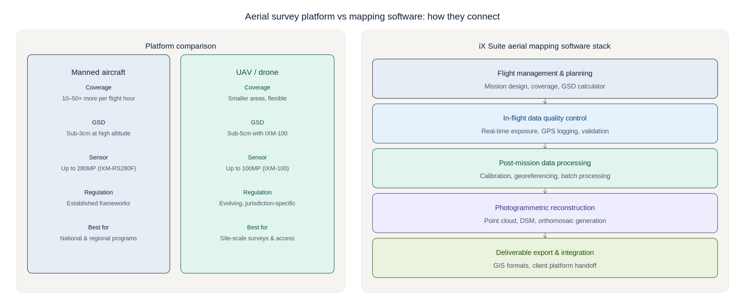
Aerial Survey: Manned Aircraft vs UAV Platforms
The choice between manned aircraft and UAV platforms for aerial survey involves five key trade-offs. First, coverage efficiency: manned platforms at cruising altitude cover 10-50× more ground per flight hour than multi-rotor UAVs, making them the only viable option for national or regional mapping programs. Second, accuracy: both platforms can achieve centimetre-level accuracy with RTK/PPK positioning and precision sensors, but manned platforms with forward motion compensation and gyro-stabilised mounts produce superior results across variable terrain.
Third, regulatory complexity: manned aerial survey operates under established aviation frameworks with well-understood regulatory requirements. UAV operations face increasingly complex regulatory environments in most jurisdictions, with airspace restrictions, operator certification requirements, and payload weight limitations that vary significantly by country and project type. Fourth, mobilisation cost: UAV systems offer dramatically lower mobilisation cost for small-area surveys, making them economically compelling for engineering projects, construction monitoring, and site surveys. Fifth, sensor quality: until recently, UAV platforms were constrained to smaller, lighter sensors with lower dynamic range. Phase One’s UAV-optimised IXM cameras change this equation, bringing 100MP image quality to drone platforms.
For most serious aerial survey operations in 2026, the answer is not either/or but a coordinated fleet approach – manned aircraft for large-area efficiency and maximum sensor quality, UAV platforms for access to confined or hazardous areas, and a unified aerial mapping software platform that processes data from both source types consistently.
Aerial Mapping Software: From Post-Processing to Real-Time Intelligence
The software layer of an aerial survey system has historically been treated as a commodity – a post-processing pipeline that converts raw sensor data into georeferenced orthomosaics, point clouds, and digital terrain models. This view underestimates the strategic importance of aerial mapping software as a competitive differentiator and operational capability multiplier.
Phase One’s iX Suite sets the standard for integrated aerial mapping software by connecting directly to Phase One’s camera hardware – enabling automated in-flight data quality checks, real-time exposure optimization, GPS event logging, and post-mission data validation before the aircraft lands. This integration eliminates the gap between data acquisition and processing that forces many operators to discover coverage gaps only after returning to base.
The competitive landscape for aerial mapping software includes specialist photogrammetry platforms such as Agisoft Metashape and Pix4D, general-purpose GIS platforms with photogrammetry modules, and cloud-based processing services. These platforms offer strong processing capabilities but lack the tight sensor integration that Phase One’s iX Suite provides – making them dependent on generic camera interfaces that cannot exploit the full capability of professional aerial survey cameras.
Comparing Sensor-Software Integration Models
The most important technical differentiator in aerial survey platform comparison is the degree of sensor-software integration. Loosely coupled systems – where any camera can theoretically be used with any software – typically sacrifice accuracy, efficiency, and data quality for flexibility. Tightly integrated systems – where the sensor and software are co-engineered – consistently deliver better results.
Phase One’s iX Suite integration with IXM cameras demonstrates this concretely: the software can access raw calibration data from the camera’s internal calibration database, enabling geometric corrections that third-party software applying generic calibration models cannot match. Boresight calibration, lens distortion correction, and rolling shutter compensation are all performed using camera-specific parameters rather than mathematical approximations.
For aerial survey operators evaluating platform options, the due diligence process should include a calibrated accuracy test over a known reference area, with independently surveyed ground control points. The difference between generic and integrated sensor-software calibration is typically visible in the results – and for applications requiring sub-10cm absolute accuracy, it is often decisive.
The Business Case for High-Resolution Aerial Survey
The economics of high-resolution aerial survey have been transformed by the dramatic reduction in data processing costs over the last five years. Cloud-based photogrammetry processing has reduced per-project processing costs by 70-80% compared to 2018 levels, while the availability of AI-accelerated point cloud classification and feature extraction has compressed deliverable production timelines from weeks to days.
This cost reduction means that the accuracy and resolution premium of Phase One’s aerial survey systems can be justified for a broader range of project types than previously. The marginal cost of acquiring 150MP imagery versus 50MP imagery is now primarily a sensor and platform cost – and the downstream value of the higher-resolution data, in terms of measurement accuracy, feature extraction quality, and deliverable reusability, consistently exceeds this premium.
For aerial survey operators seeking to differentiate their service offering, Phase One’s camera systems provide a genuine technical differentiator that clients can understand and value: more pixels, more detail, more accurate measurements, and deliverables that remain fit-for-purpose as client analytical requirements evolve.